IMAGES TAKEN NEAR TO
Myton Crofts, LEAMINGTON SPA, CV31 3NZ
Introduction
This page details the photographs taken nearby to Myton Crofts, CV31 3NZ by members of the Geograph project.
The Geograph project started in 2005 with the aim of publishing, organising and preserving representative images for every square kilometre of Great Britain, Ireland and the Isle of Man.

There are currently over 7.5m images from over14,400 individuals and you can help contribute to the project by visiting https://www.geograph.org.uk
Image Map
Images are licensed for reuse under creativecommons.org/licenses/by-sa/2.0
Notes
- Clicking on the map will re-center to the selected point.
- The higher the marker number, the further away the image location is from the centre of the postcode.
Image Listing (416 Images Found)
Images are licensed for reuse under creativecommons.org/licenses/by-sa/2.0
Image
Details
Distance
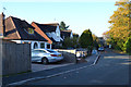
1

The east side of Myton Crofts, Warwick
Myton Crofts is a residential cul-de-sac off the north side of Myton Road. It loops round a triangle of land bounded by trees, left. Whether the triangle is a private garden or a communal open space for residents is not known. It first appears on an OS County Series map of 1938; the map before that was 1926.
Image: © Robin Stott
Taken: 31 Oct 2015
0.01 miles
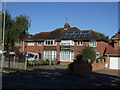
2

The triangle of land bounded by Myton Crofts, Warwick
Myton Crofts is a residential cul-de-sac off the north side of Myton Road. It loops round this triangle of land bounded by trees. It was developed on an open field, first appearing on an OS County Series map of 1938; the map before that was 1926. As all the houses have gardens it may be that this is the residue of the original owner's land: detached private garden ground.
Image: © Robin Stott
Taken: 31 Oct 2015
0.02 miles
3
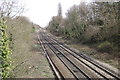
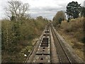
Railway, Myton
The former GWR climbs towards Leamington station. Image
Trains sometimes wait on this stretch to get through the junction with the line from Coventry.
Image: © Robin Stott
Taken: 24 Mar 2009
0.04 miles
4

Ford's car park, Prince's Drive, Leamington Spa
Ford's foundry closed in 2008. The staff car park - a vast expanse of tarmac - is seen here from a train as it waited to enter Leamington station. The building beyond is the back of Homebase, Myton Road.
Image: © Robin Stott
Taken: 24 Mar 2009
0.04 miles
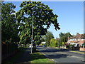
5
The west side of Myton Crofts, Warwick
Myton Crofts is a residential cul-de-sac off the north side of Myton Road. It loops round a triangle of land bounded by trees, right. Whether the triangle is a private garden or a communal open space for residents is not known. It first appears on an OS County Series map of 1938; the map before that was 1926.
Image: © Robin Stott
Taken: 31 Oct 2015
0.04 miles
7

Ford's staff car park, Prince's Drive, Leamington Spa
The car park was beyond the white building.
Side of Homebase, Myton Road, in sun, top left. Warwick begins at the trees, which are on a bund, top.
Image: © Robin Stott
Taken: 22 Mar 2009
0.05 miles
9

Fallen catkins of Sweet Chestnut, Warwick
By Myton Road near Lidl. Note the characteristic twist of the trunk.
Image: © Robin Stott
Taken: 23 Jul 2022
0.07 miles
10
Southbound container freight approaching Leamington Spa
At the front of this train, probably heading for Southampton, there were up to eight containers of various sizes (orange smudge in the distance) followed by at least sixteen empty wagons capable of carrying a full-size shipping container. This could be interpreted as evidence of reduced export traffic since the trade agreement between the UK and the European Union before Christmas 2020; it may just be a quiet time of year for international trade; or it may be that some exporting companies have closed down for the duration of the Covid-19 pandemic. See also Image
Image: © Robin Stott
Taken: 24 Feb 2021
0.08 miles