IMAGES TAKEN NEAR TO
Tachbrook Road, LEAMINGTON SPA, CV31 3DQ
Introduction
This page details the photographs taken nearby to Tachbrook Road, CV31 3DQ by members of the Geograph project.
The Geograph project started in 2005 with the aim of publishing, organising and preserving representative images for every square kilometre of Great Britain, Ireland and the Isle of Man.

There are currently over 7.5m images from over14,400 individuals and you can help contribute to the project by visiting https://www.geograph.org.uk
Image Map (Loading...)


Getting Data...Please wait
Leaflet Map data © OpenStreetMap
Images are licensed for reuse under creativecommons.org/licenses/by-sa/2.0
Notes
- Clicking on the map will re-center to the selected point.
- The higher the marker number, the further away the image location is from the centre of the postcode.
Image Listing (41 Images Found)
Images are licensed for reuse under creativecommons.org/licenses/by-sa/2.0
Image
Details
Distance
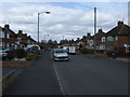
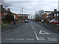
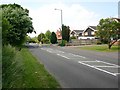
2
Junction of Tachbrook Road and Medley Grove, Whitnash
Looking NNE up Tachbrook Road.
Image: © David P Howard
Taken: 4 Jun 2010
0.09 miles
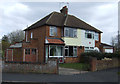
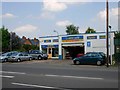
3
Tachbrook Road, Whitnash
Looking NNE along Tachbrook Road from near the junction with Ashford Road on the edge of Whitnash.
Image: © David P Howard
Taken: 4 Jun 2010
0.10 miles
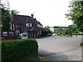
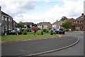
4
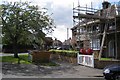
Corner of Landor Road and St Catherine's Close, Whitnash
Image: © Robin Stott
Taken: 22 Aug 2009
0.13 miles