IMAGES TAKEN NEAR TO
Culworth Close, LEAMINGTON SPA, CV31 3DJ
Introduction
This page details the photographs taken nearby to Culworth Close, CV31 3DJ by members of the Geograph project.
The Geograph project started in 2005 with the aim of publishing, organising and preserving representative images for every square kilometre of Great Britain, Ireland and the Isle of Man.

There are currently over 7.5m images from over14,400 individuals and you can help contribute to the project by visiting https://www.geograph.org.uk
Image Map (Loading...)


Getting Data...Please wait
Leaflet Map data © OpenStreetMap
Images are licensed for reuse under creativecommons.org/licenses/by-sa/2.0
Notes
- Clicking on the map will re-center to the selected point.
- The higher the marker number, the further away the image location is from the centre of the postcode.
Image Listing (51 Images Found)
Images are licensed for reuse under creativecommons.org/licenses/by-sa/2.0
Image
Details
Distance
1
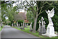
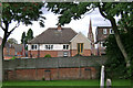
Mortuary chapel, Leamington Cemetery, Brunswick Street
One of the two chapels, both closed. The cemetery was opened in 1852.
Image: © Robin Stott
Taken: 3 Aug 2009
0.05 miles
2
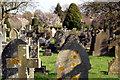
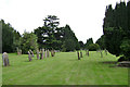
Sea of stone
Leamington Spa cemetery in the afternoon light. This large cemetery has graves going back to the earliest days of the spa town.
Image: © Colin Craig
Taken: 20 Mar 2009
0.07 miles
3
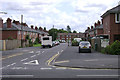
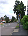
Windmill Road, Leamington Spa
Old photographs show a windmill further down Tachbrook Road (off to the right). It was finally demolished in 1968 but is remembered in the names of this road and the Windmill Inn. The trees in the background are in Leamington Cemetery, Brunswick Street Image mostly.
Image: © Robin Stott
Taken: 30 Jul 2009
0.09 miles
4
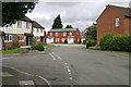
Brakesmead, Leamington Spa
This small estate was developed, controversially, on the home ground of a local football team, Leamington Brakes. They were sponsored by major local employer Lockheed Hydraulic Brakes (later known as Automotive Products or AP) and remembered in the name Lockheed Close, behind the camera. Brakesmead is a turning off Culworth Close, centre.
Image: © Robin Stott
Taken: 30 Jul 2009
0.09 miles
5
Rear of St Helen's Road, Leamington Spa
Seen from Leamington Cemetery, with a glimpse of the spire of St John's Church, Tachbrook Street Image
Image: © Robin Stott
Taken: 3 Aug 2009
0.10 miles
6
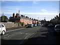
Brunswick Street, Leamington Spa
The street heads south to Whitnash. The tall evergreen, right, marks the edge of Leamington Cemetery.
Image: © Robin Stott
Taken: 3 Aug 2009
0.11 miles
7
Leamington Cemetery, Brunswick Street, Leamington Spa
An older part of the cemetery, which was opened in 1852.
Image: © Robin Stott
Taken: 3 Aug 2009
0.11 miles
8
Windmill Road, Leamington Spa
A residential cul de sac off Tachbrook Road.
Image: © Richard Vince
Taken: 4 Mar 2017
0.11 miles
9
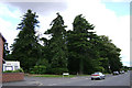
The Arboretum by St Helen's Road, Leamington Spa
The arboretum, now public open space, forms the centrepiece of the Wych Elm Drive estate, built on the site of the Royal Midland Counties Home for Incurables. The arboretum was planted by John Hitchman, 19th century doctor and mad about trees, in the grounds of his hydropathic establishment. It has fine examples of Douglas Fir, cedars, Wellingtonias and other exotic conifers.
Image: © Robin Stott
Taken: 24 Jul 2009
0.12 miles
10
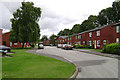
Culworth Close, Leamington Spa
Near the end of this long close of rented houses and flats. The trees in the background are in Leamington Cemetery, Brunswick Street Image mostly.
Image: © Robin Stott
Taken: 30 Jul 2009
0.13 miles