IMAGES TAKEN NEAR TO
Yew Tree Court, Tachbrook Street, LEAMINGTON SPA, CV31 3BF
Introduction
This page details the photographs taken nearby to Yew Tree Court, Tachbrook Street, CV31 3BF by members of the Geograph project.
The Geograph project started in 2005 with the aim of publishing, organising and preserving representative images for every square kilometre of Great Britain, Ireland and the Isle of Man.

There are currently over 7.5m images from over14,400 individuals and you can help contribute to the project by visiting https://www.geograph.org.uk
Image Map
Images are licensed for reuse under creativecommons.org/licenses/by-sa/2.0
Notes
- Clicking on the map will re-center to the selected point.
- The higher the marker number, the further away the image location is from the centre of the postcode.
Image Listing (63 Images Found)
Images are licensed for reuse under creativecommons.org/licenses/by-sa/2.0
Image
Details
Distance
1
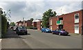
Southwest and uphill on Tachbrook Street, Leamington
Image: © Robin Stott
Taken: 1 May 2019
0.03 miles
2
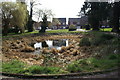
The pond lives on
A pond which used to form part of the grounds of the Royal Midland Counties Hospital in Leamington Spa. The hospital was demolished some years ago and new houses built over the site. The pond survived and was full of frogs when the pic was taken.
Image: © Colin Craig
Taken: 17 Mar 2009
0.04 miles
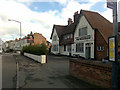
4
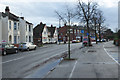
Tachbrook Road, Leamington Spa
Looking towards the Wheatsheaf pub.
Image: © Stephen McKay
Taken: 22 Nov 2014
0.05 miles
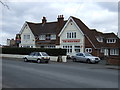
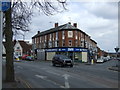
6
The Wheatsheaf
Tachbrook Road, Leamington Spa.
Image: © David Lally
Taken: 8 Apr 2009
0.05 miles
7
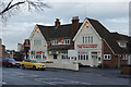
The Wheatsheaf, Leamington Spa
A Banks's pub on Tachbrook Road built in the inter-war period.
Image: © Stephen McKay
Taken: 22 Nov 2014
0.05 miles
8
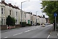
Tachbrook Road, Leamington Spa
Terraced houses with staggered fronts are characteristic of the north end of Tachbrook Road.
Image: © Robin Stott
Taken: 24 Aug 2009
0.05 miles
9
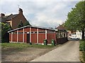
Rear of St John?s Church Hall, Tachbrook Street, Leamington
Transformed into a polling station for local elections on 2 May 2019. It has been the church hall since 1957. It took the place of the Wise Hall, the parish function room, that was a school for a while. Thanks to Father Stephen for this information.
The Wise family were one of the four main landowners in Leamington in the early nineteenth century. They had connections to St John's. Mrs Matthew Wise gave money towards the building of the church around 1875. Her son, the Reverend W G Wise, became parish priest in 1882. Image
Image: © Robin Stott
Taken: 1 May 2019
0.06 miles
10
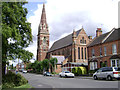
Church of St John the Baptist, Tachbrook Street, Leamington Spa
Begun in 1877 and completed in 1888, St John's is said to be the finest work of local architect John Cundall. Characteristically, he has placed the tower to the side of the nave so that it forms a powerful focal point in the long view from the top of the street (to the right of the camera). The spire is a landmark for miles around.
Image: © Robin Stott
Taken: 24 Jul 2009
0.07 miles