IMAGES TAKEN NEAR TO
Southway, LEAMINGTON SPA, CV31 2PE
Introduction
This page details the photographs taken nearby to Southway, CV31 2PE by members of the Geograph project.
The Geograph project started in 2005 with the aim of publishing, organising and preserving representative images for every square kilometre of Great Britain, Ireland and the Isle of Man.

There are currently over 7.5m images from over14,400 individuals and you can help contribute to the project by visiting https://www.geograph.org.uk
Image Map
Images are licensed for reuse under creativecommons.org/licenses/by-sa/2.0
Notes
- Clicking on the map will re-center to the selected point.
- The higher the marker number, the further away the image location is from the centre of the postcode.
Image Listing (37 Images Found)
Images are licensed for reuse under creativecommons.org/licenses/by-sa/2.0
Image
Details
Distance
1
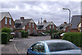
Grosvenor Road, Leamington Spa
The place to go if you like humps. The trees with red bits are Tree of Heaven (Ailanthus altissima) and the red bits are the developing fruits.
Image: © Robin Stott
Taken: 3 Aug 2009
0.05 miles
3
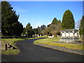
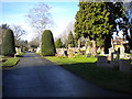
Leamington Spa Cemetery (2)
Off Brunswick Street.
Image: © Richard Vince
Taken: 4 Mar 2017
0.06 miles
4
Leamington Spa Cemetery (1)
Off Brunswick Street.
Image: © Richard Vince
Taken: 4 Mar 2017
0.07 miles
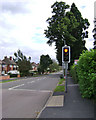
6
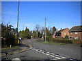
Brunswick Street, Leamington Spa (1)
Looking towards the town centre from the end of Masters Road.
Image: © Richard Vince
Taken: 4 Mar 2017
0.09 miles
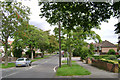
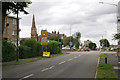
7
Southway, Leamington Spa
The two trees forming dense dark blobs are varieties of hornbeam, Carpinus betulus 'Fastigiata'. Years ago there was a fashion for planting them in public open spaces and housing estates.
Image: © Robin Stott
Taken: 3 Aug 2009
0.10 miles
8
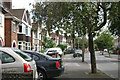
Brunswick Street, Leamington Spa
At the junction with St Helen's Road, left, and Grosvenor Road, right. The church spire is that of St John's, Tachbrook Street Image The tower in the distance, at the focal point of the street (not the block of flats), is Leamington Town Hall north of the river Image Opened in 1884, it replaced the old town hall south of the river. It is said that the tower was positioned by design to be visible from the southern part of the town.
Image: © Robin Stott
Taken: 3 Aug 2009
0.11 miles
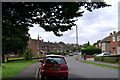
9
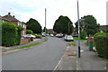
Brunswick Street, Leamington Spa
The street heads south to Whitnash. The tall evergreen, right, marks the edge of Leamington Cemetery.
Image: © Robin Stott
Taken: 3 Aug 2009
0.11 miles