IMAGES TAKEN NEAR TO
Wright Gardens, LEAMINGTON SPA, CV31 2FP
Introduction
This page details the photographs taken nearby to Wright Gardens, CV31 2FP by members of the Geograph project.
The Geograph project started in 2005 with the aim of publishing, organising and preserving representative images for every square kilometre of Great Britain, Ireland and the Isle of Man.

There are currently over 7.5m images from over14,400 individuals and you can help contribute to the project by visiting https://www.geograph.org.uk
Image Map
Images are licensed for reuse under creativecommons.org/licenses/by-sa/2.0
Notes
- Clicking on the map will re-center to the selected point.
- The higher the marker number, the further away the image location is from the centre of the postcode.
Image Listing (26 Images Found)
Images are licensed for reuse under creativecommons.org/licenses/by-sa/2.0
Image
Details
Distance
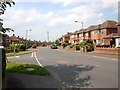
1
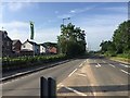
South on Tachbrook Road towards Harbury Lane junction, south Leamington
On the left, new houses in a close off Lancaster Way, built by Persimmon Homes.
Image: © Robin Stott
Taken: 3 Jun 2018
0.11 miles
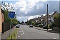
2
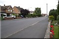
Landor Road, Whitnash
The name recalls the poet Walter Savage Landor, who has local associations.
Image: © Robin Stott
Taken: 22 Aug 2009
0.12 miles
3
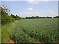
First field on the edge of Whitnash
The hedgeline on the left is the end of the gardens on Ashford Road.
Image: © David P Howard
Taken: 4 Jun 2010
0.12 miles
4
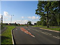
Junction of Tachbrook Road and Harbury Lane looking southwest, south Leamington
Harbury Lane has for years marked the southern edge of the Leamington and Warwick urban areas. No longer: the south side of the lane is becoming a bewildering patchwork of new housing estates by several developers. Only three of them are advertised here: Taylor Wimpey/Meadowsweet Farm; Persimmon Homes/Bishops Gate; and local A.C.Lloyd/Oakley Grove.
Image: © Robin Stott
Taken: 3 Jun 2018
0.13 miles
5
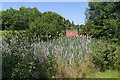
Interceptor pond on Heathcote Park Estate
A surface water interceptor pond at the edge of the housing estate off Tachbrook Road.
Image: © David P Howard
Taken: 6 Jun 2016
0.13 miles
6
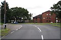
Junction of Landor Road and Ashford Road, Whitnash
Looking north up Landor Road.
Image: © David P Howard
Taken: 4 Jun 2010
0.14 miles
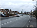
7
Ashford Road, Whitnash
Provides access to and from the south-west of Whitnash: always busy.
Image: © Robin Stott
Taken: 22 Aug 2009
0.14 miles
9
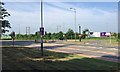
Tachbrook Crossroads
This junction has recently been remodelled and traffic lights installed due to the huge increase in traffic in the area.
Image: © David Stowell
Taken: 26 May 2005
0.15 miles
10
Landor House, Whitnash
Landor Road, which circulates round the west side of Whitnash, here at its south end becomes Coppice Road.
Image: © Robin Stott
Taken: 22 Aug 2009
0.15 miles