IMAGES TAKEN NEAR TO
Fosse Way, LEAMINGTON SPA, CV31 1XH
Introduction
This page details the photographs taken nearby to Fosse Way, CV31 1XH by members of the Geograph project.
The Geograph project started in 2005 with the aim of publishing, organising and preserving representative images for every square kilometre of Great Britain, Ireland and the Isle of Man.

There are currently over 7.5m images from over14,400 individuals and you can help contribute to the project by visiting https://www.geograph.org.uk
Image Map
Images are licensed for reuse under creativecommons.org/licenses/by-sa/2.0
Notes
- Clicking on the map will re-center to the selected point.
- The higher the marker number, the further away the image location is from the centre of the postcode.
Image Listing (3 Images Found)
Images are licensed for reuse under creativecommons.org/licenses/by-sa/2.0
Image
Details
Distance
1
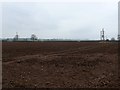
Countryside near Whitnash
These fields are just next to the Fosse Way. In the distance can be seen the shining roof of the glasshouses at Sharmer farm.
Image: © Nigel Mykura
Taken: 20 Feb 2011
0.13 miles
2
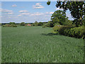
Sharmer House across a wheatfield
The vegetation on the left surrounds a pond. The hedgerow on the right winds east towards the Fosse Way.
Image: © Robin Stott
Taken: 30 May 2010
0.19 miles
3
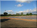
Lower Fosse Farm
Some intensive farming in preparation, with the buildings of neighbouring Sharmer Farm visible in the distance
Image: © David Stowell
Taken: 26 May 2005
0.24 miles