IMAGES TAKEN NEAR TO
Longfield Road, LEAMINGTON SPA, CV31 1XB
Introduction
This page details the photographs taken nearby to Longfield Road, CV31 1XB by members of the Geograph project.
The Geograph project started in 2005 with the aim of publishing, organising and preserving representative images for every square kilometre of Great Britain, Ireland and the Isle of Man.

There are currently over 7.5m images from over14,400 individuals and you can help contribute to the project by visiting https://www.geograph.org.uk
Image Map (Loading...)


Getting Data...Please wait
Leaflet Map data © OpenStreetMap
Images are licensed for reuse under creativecommons.org/licenses/by-sa/2.0
Notes
- Clicking on the map will re-center to the selected point.
- The higher the marker number, the further away the image location is from the centre of the postcode.
Image Listing (26 Images Found)
Images are licensed for reuse under creativecommons.org/licenses/by-sa/2.0
Image
Details
Distance
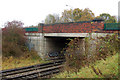
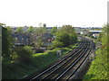
1
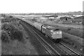
View from Prospect Road railway bridge
Looking NNW from the Prospect Road bridge over the railway lines.
On the right is the Sydenham Industrial Estate being constructed, with Highdown Road in the centre.
Image: © David P Howard
Taken: Unknown
0.05 miles
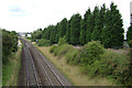
2
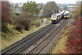
Trains passing north of Prospect Road
A down (northbound) Cross Country 'Voyager' unit passing an up (southbound) Chiltern Railways Class 165 unit seen from Prospect Road railway bridge, Leamington Spa.
Image: © Andy F
Taken: 10 Nov 2009
0.05 miles
3
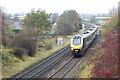
An up Cross Country 'Voyager' approaching Prospect Road bridge
Image: © Andy F
Taken: 10 Nov 2009
0.07 miles
4
Looking east across the railway bridge on Prospect Road
Image: © Andy F
Taken: 10 Nov 2009
0.07 miles
5
North side of bridge carrying Prospect Road over the railway
Image: © Andy F
Taken: 10 Nov 2009
0.08 miles
6
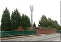
Tree screen, rear of Sydenham Industrial Estate, Leamington Spa
Seen from the Prospect Road bridge over the Leamington-Banbury line.
Image: © Robin Stott
Taken: 3 Aug 2009
0.08 miles
7
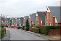
Sydenham Industrial Estate
This large industrial Estate on the east side of Leamington Spa is on a triangle of land bounded by the Grand Union canal on the north, the railway track on the west and the Sydenham residential estate on the east.
Image: © Nigel Mykura
Taken: 28 Aug 2011
0.08 miles
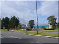
8
Looking north along Waverley Road, Leamington Spa
Image: © Andy F
Taken: 10 Nov 2009
0.09 miles
9
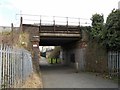
Leamington-Banbury Line
Bridge over a path linking Waverley Road and Jenton Road.
Image: © Ian Rob
Taken: 19 Apr 2013
0.11 miles
10
GWR main line, Leamington Spa
The former Great Western Railway main line from London to Birmingham approaching Leamington Spa. The tower of the parish church can be seen in the distance. The industrial units on the right are the site of Leamington junction and the GWR loco sheds.
Image: © David Stowell
Taken: 29 Apr 2005
0.12 miles