IMAGES TAKEN NEAR TO
Plymouth Place, LEAMINGTON SPA, CV31 1HW
Introduction
This page details the photographs taken nearby to Plymouth Place, CV31 1HW by members of the Geograph project.
The Geograph project started in 2005 with the aim of publishing, organising and preserving representative images for every square kilometre of Great Britain, Ireland and the Isle of Man.

There are currently over 7.5m images from over14,400 individuals and you can help contribute to the project by visiting https://www.geograph.org.uk
Image Map (Loading...)


Getting Data...Please wait
Leaflet Map data © OpenStreetMap
Images are licensed for reuse under creativecommons.org/licenses/by-sa/2.0
Notes
- Clicking on the map will re-center to the selected point.
- The higher the marker number, the further away the image location is from the centre of the postcode.
Image Listing (266 Images Found)
Images are licensed for reuse under creativecommons.org/licenses/by-sa/2.0
Image
Details
Distance
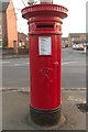
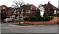
2
Radford Road
Near the junction with Davidson Avenue. A closer view of the postbox can be seen here: Image
Image: © Mark Anderson
Taken: 17 Nov 2018
0.05 miles
3
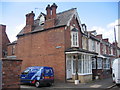
Sabin and Son, Farley Street, Royal Leamington Spa
These old shop premises have been converted into housing, however the shop proprietors name still survives on the end of the building as do the curiously carved wooden pillars supporting the bay roof.
Image: © David Stowell
Taken: 7 Aug 2005
0.07 miles
4
Farley Street
An interesting old house on Farley Street, possibly once associated with the larger properties behind on Willes Road and now surrounded and to some extent dwarfed by more modern developments.
Image: © David Stowell
Taken: 7 Aug 2005
0.07 miles
5
Corner of Russell Terrace and Farley Street, Royal Leamington Spa
Russell Terrace is on the left.
Image: © Jaggery
Taken: 19 Apr 2015
0.07 miles
6
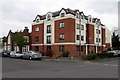
Squirhill Place, Royal Leamington Spa
Flats on the corner of Farley Street and Russell Terrace.
Image: © Jaggery
Taken: 19 Apr 2015
0.08 miles
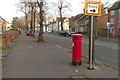
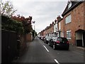
7
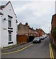
East along Gordon Street, Royal Leamington Spa
Narrow street aligned parallel with New Street which is 50 metres to the north.
Image: © Jaggery
Taken: 19 Apr 2015
0.08 miles
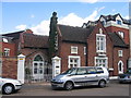
8
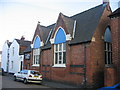
Church of God of Prophecy
This old school building, formerly St Mary's Girls and Infants, at the eastern end of New Street has found a new use as a church centre.
Image: © David Stowell
Taken: 2 Oct 2005
0.08 miles
9
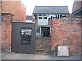
Old workshops, New Street
Another of the interesting little workshops/stable hidden away in the side streets. The site of this one is now cleared, no doubt to squeeze in yet another couple of apartments!
Image: © David Stowell
Taken: 2 Oct 2005
0.08 miles
10
West along Gordon Street, Royal Leamington Spa
From the Farley Street end.
Image: © Jaggery
Taken: 19 Apr 2015
0.08 miles