IMAGES TAKEN NEAR TO
Willes Terrace, LEAMINGTON SPA, CV31 1DL
Introduction
This page details the photographs taken nearby to Willes Terrace, CV31 1DL by members of the Geograph project.
The Geograph project started in 2005 with the aim of publishing, organising and preserving representative images for every square kilometre of Great Britain, Ireland and the Isle of Man.

There are currently over 7.5m images from over14,400 individuals and you can help contribute to the project by visiting https://www.geograph.org.uk
Image Map
Images are licensed for reuse under creativecommons.org/licenses/by-sa/2.0
Notes
- Clicking on the map will re-center to the selected point.
- The higher the marker number, the further away the image location is from the centre of the postcode.
Image Listing (91 Images Found)
Images are licensed for reuse under creativecommons.org/licenses/by-sa/2.0
Image
Details
Distance
1
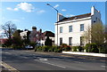
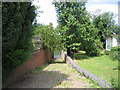
Willes Terrace
Looking east towards Leam Terrace East, with the edge of a private open space, left.
Image: © Robin Stott
Taken: 31 Oct 2009
0.01 miles
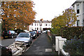
2
Leam Terrace East
One of 19th century Leamington's most spacious roads. Houses, mainly on the north side (right) come in all varieties. The Willes Terrace private open space is on the left.
Image: © Robin Stott
Taken: 31 Oct 2009
0.01 miles
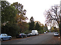
3
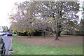
Private open space opposite Willes Terrace
One of three remaining shared private open spaces in Leamington. Until around 1948 Clarendon Square and Christchurch Gardens were communal open spaces open only to residents of the surrounding properties. Some London squares still have this status.
Image: © Robin Stott
Taken: 31 Oct 2009
0.01 miles
4
Elephant Walk, Royal Leamington Spa
This slope down to the river just below the Mill Bridge Weir got its name from the practice of Heigler's Equestrian Circus who, in the mid 1800s, used to walk their elephants through the town every day to the river for washing and watering! See also Image for the Elephant House and Image for more historical detail
Image: © David Stowell
Taken: 16 Jul 2005
0.05 miles

6
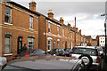
Beaconsfield Street
Looking from the junction with Northcote Street towards Leam Terrace East. This is one of several streets of densely-packed terraced housing between Leam Terrace East and Willes Road. These are neither two-up, two-downs nor are they cheap, judging by the cars parked here on a Saturday afternoon.
Image: © Robin Stott
Taken: 31 Oct 2009
0.07 miles

8
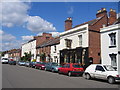
Leam Terrace - The New Inn
Leam Terrace is a wide road sweeping around the NE quadrant of this square and the picture shows the CAMRA listed New Inn, renowned for its variety of Ales on sale.
Image: © David Stowell
Taken: 7 Aug 2005
0.09 miles
9
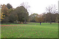
Crabtree Meadow
While Welches Meadow is managed as a flood-meadow for wildlife (insects, birds, bats) the adjoining Crabtree Meadow is managed as parkland. It was assembled from several small parcels of land behind Leam Terrace East; they included some allotments. The occasional flourishing fruit tree may be found in the scrub boundary between the two meadows.
Image: © Robin Stott
Taken: 31 Oct 2009
0.09 miles