IMAGES TAKEN NEAR TO
Mill Road, LEAMINGTON SPA, CV31 1BP
Introduction
This page details the photographs taken nearby to Mill Road, CV31 1BP by members of the Geograph project.
The Geograph project started in 2005 with the aim of publishing, organising and preserving representative images for every square kilometre of Great Britain, Ireland and the Isle of Man.

There are currently over 7.5m images from over14,400 individuals and you can help contribute to the project by visiting https://www.geograph.org.uk
Image Map (Loading...)


Getting Data...Please wait
Leaflet Map data © OpenStreetMap
Images are licensed for reuse under creativecommons.org/licenses/by-sa/2.0
Notes
- Clicking on the map will re-center to the selected point.
- The higher the marker number, the further away the image location is from the centre of the postcode.
Image Listing (838 Images Found)
Images are licensed for reuse under creativecommons.org/licenses/by-sa/2.0
Image
Details
Distance
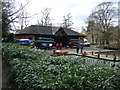
2
Boat Hire, Mill Gardens
The Boating Centre, situated on one of the remaining ponds adjacent to, and connected with the River Leam. At one time these ponds fed an old water mill and were later used as reservoirs for Leamington's first public water supply. Today boats can be hired by the hour for short trips on the river.
Image: © David Stowell
Taken: 16 Jul 2005
0.02 miles
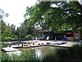
3
![Leamington Spa Gardens [8]](https://s0.geograph.org.uk/geophotos/06/40/28/6402804_002ba384_120x120.jpg)
Leamington Spa Gardens [8]
Seen from Jephson Gardens, looking across the River Leam, is this footbridge in Mill Gardens. There are some colourful vessels for hire seen under the bridge.
Willes Bridge, over the River Leam, was erected in 1827, improved in 1876, repaired in the 20th century and has recently (2015) been restored. Listed, grade II, with details at: https://historicengland.org.uk/listing/the-list/list-entry/1381579
The spa waters of Leamington Priors had been known in Roman times but their rediscovery in 1784 led to their commercialisation with six new wells drilled. Rapid expansion followed and the town became Royal Leamington Spa after Queen Victoria granted use of the prefix in 1838. Renowned for its Regency architecture and spacious parks and ornamental gardens on either side of the River Leam, Leamington is today a residential and resort town.
Image: © Michael Dibb
Taken: 8 Feb 2020
0.03 miles
4
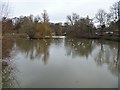
Leamington's river [3]
The River Leam is seen from Mill Bridge looking upstream. The river rises at Hellidon, Northamptonshire and flows into the River Avon near Warwick.
The spa waters of Leamington Priors had been known in Roman times but their rediscovery in 1784 led to their commercialisation with six new wells drilled. Rapid expansion followed and the town became Royal Leamington Spa after Queen Victoria granted use of the prefix in 1838. Renowned for its Regency architecture and spacious parks and ornamental gardens on either side of the River Leam, Leamington is today a residential and resort town.
Image: © Michael Dibb
Taken: 8 Feb 2020
0.04 miles
6
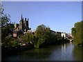
Leamington Riverside
Photo taken from the approach to Jephson Gardens, with Victoria Bridge far right, and All Saints Church left of centre.
Image: © Chris Cursley
Taken: 15 May 2010
0.04 miles
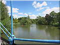
7

River Leam, Royal Leamington Spa
Seen from the Mill Passage bridge. This was on the Geograph 12th birthday meeting.
Image: © Chris Allen
Taken: 4 Mar 2017
0.04 miles
8
River Leam by Jephson Gardens
The River Leam rises at Hellidon Hill in Northamptonshire and joins the Avon between Leamington and Warwick.
It looks very tranquil here, but other pictures nearby show it seriously flooding the town centre.
Image: © Des Blenkinsopp
Taken: 24 May 2016
0.05 miles
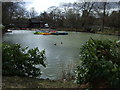
9
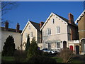
Leam Terrace
A couple of excellent examples of the various styles of Victorian town houses that line much of Leam Terrace.
Image: © David Stowell
Taken: 28 Jan 2006
0.05 miles
10
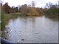
River Leam View
The view upstream of the River Leam from the Mill Bridge at Royal Leamington Spa.
Image: © Gordon Griffiths
Taken: 1 Dec 2012
0.05 miles