IMAGES TAKEN NEAR TO
Star Corner, RUGBY, CV23 8UD
Introduction
This page details the photographs taken nearby to Star Corner, CV23 8UD by members of the Geograph project.
The Geograph project started in 2005 with the aim of publishing, organising and preserving representative images for every square kilometre of Great Britain, Ireland and the Isle of Man.

There are currently over 7.5m images from over14,400 individuals and you can help contribute to the project by visiting https://www.geograph.org.uk
Image Map
Images are licensed for reuse under creativecommons.org/licenses/by-sa/2.0
Notes
- Clicking on the map will re-center to the selected point.
- The higher the marker number, the further away the image location is from the centre of the postcode.
Image Listing (19 Images Found)
Images are licensed for reuse under creativecommons.org/licenses/by-sa/2.0
Image
Details
Distance
1
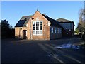
Barby Village Hall
Illuminated by the low winter sun,between Kilsby Road and Church Walk.
Image: © Ian Rob
Taken: 5 Dec 2012
0.05 miles
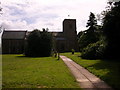

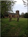
6
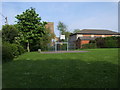
Barby Playing Fields
Barby playing fields by St Mary's Church
Image: © Shaun Ferguson
Taken: 9 May 2016
0.08 miles
8

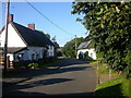
Barby-Daventry Road
A typical autumn scene at the junction with Kilsby Road.
Image: © Ian Rob
Taken: 23 Oct 2012
0.08 miles