IMAGES TAKEN NEAR TO
London Road, RUGBY, CV23 8AQ
Introduction
This page details the photographs taken nearby to London Road, CV23 8AQ by members of the Geograph project.
The Geograph project started in 2005 with the aim of publishing, organising and preserving representative images for every square kilometre of Great Britain, Ireland and the Isle of Man.

There are currently over 7.5m images from over14,400 individuals and you can help contribute to the project by visiting https://www.geograph.org.uk
Image Map
Images are licensed for reuse under creativecommons.org/licenses/by-sa/2.0
Notes
- Clicking on the map will re-center to the selected point.
- The higher the marker number, the further away the image location is from the centre of the postcode.
Image Listing (23 Images Found)
Images are licensed for reuse under creativecommons.org/licenses/by-sa/2.0
Image
Details
Distance
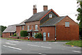
3
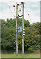
Willoughby-London Road
House at the crossroads on the A45.Taken from just outside the square.
Image: © Ian Rob
Taken: 25 Feb 2008
0.02 miles
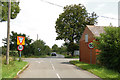
6
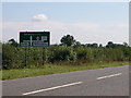
Willoughby
A45 nearing crossroads at Willoughby.
Image: © Ian Rob
Taken: 12 Sep 2005
0.14 miles
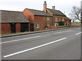
7

Longdown Lane
From Willoughby towards Barby and Kilsby.
Image: © Robin Webster
Taken: 24 Jun 2017
0.16 miles
8
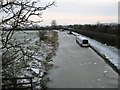
Willoughby Wharf
Narrowboats on the frozen Oxford Canal.
Image: © Ian Rob
Taken: 30 Nov 2010
0.21 miles
9
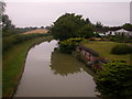
Oxford Canal near Willoughby
Showing rear of Navigation cottage. Second hedgerow on left is Great Central Railway (disused). For a winter view Image
Image: © Ian Rob
Taken: 27 Jul 2005
0.21 miles
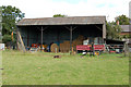
10
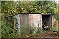
Shed behind the pond at Willoughby
In October 2009, the village pond at Willoughby (see [http://www.geograph.org.uk/photo/1396006] and [http://www.geograph.org.uk/photo/1395999] ) was drained so that years of accumulated silt could be dredged out. The silt was spread over a small paddock behind the pond.
Image: © Andy F
Taken: 15 Oct 2009
0.22 miles