IMAGES TAKEN NEAR TO
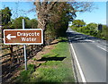
Draycote Water, RUGBY, CV23 8AB
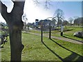
Introduction
This page details the photographs taken nearby to Draycote Water, CV23 8AB by members of the Geograph project.
The Geograph project started in 2005 with the aim of publishing, organising and preserving representative images for every square kilometre of Great Britain, Ireland and the Isle of Man.

There are currently over 7.5m images from over14,400 individuals and you can help contribute to the project by visiting https://www.geograph.org.uk
Image Map
Images are licensed for reuse under creativecommons.org/licenses/by-sa/2.0
Notes
- Clicking on the map will re-center to the selected point.
- The higher the marker number, the further away the image location is from the centre of the postcode.
Image Listing (55 Images Found)
Images are licensed for reuse under creativecommons.org/licenses/by-sa/2.0
Image
Details
Distance
1
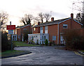
Draycote Water, staff houses
Staff houses beside the entrance road into Draycote water reservoir and country park.
Image: © Andy F
Taken: 18 Jan 2009
0.06 miles
2
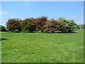
Different shades of May
Several different shades of hawthorn blossom in this group on the picnic area at Draycote Water.
Image: © E Gammie
Taken: 24 May 2010
0.06 miles
3
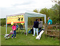
Draycote Water - charity fundraising booth
A fundraising stall run at Draycote water by the Chernobyl Children's Project UK. The charity raises money to provide recuperative holidays in the UK for children from Belarus who were affected by contamination from the Chernobyl nuclear power plant accident.
Image: © Andy F
Taken: 10 May 2009
0.08 miles
5
Draycote Water, play area
At Draycote Water Country Park: https://www.therugbytown.co.uk/directory_record/10048/draycote_water_country_park
Image: © Mike Faherty
Taken: 18 Nov 2018
0.09 miles
6
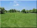
Picnic area, Draycote Water
Part of the country park at the southern end of Draycote Water reservoir.
Image: © E Gammie
Taken: 24 May 2010
0.09 miles
7
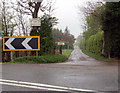
Hensborough Farm entrance, Kites Hardwick
Looking west along the driveway to Hensborough Farm from the A426 road a few hundred metres north of Kites Hardwick village.
Image: © Andy F
Taken: 16 Apr 2009
0.09 miles
8
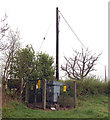
Transformer near Kites Hardwick
This electricity supply transformer and switchgear, operated by Central Networks, stands beside the A426 road north of Kites Hardwick village.
Image: © Andy F
Taken: 16 Apr 2009
0.10 miles
9
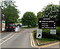
Draycote Water carpark entrance
The main entrance to Draycote Water reservoir and country park.
Image: © Andy F
Taken: 10 May 2009
0.10 miles
10
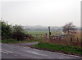
Foxley Farm, old entrance from A426
This track is the former entrance to Foxley Farm from the A426 (visible in the foreground). Because this entrance is on a sharp bend in the busy A426, a new track and entrance were constructed three hundred metres north on the A426.
Image: © Andy F
Taken: 16 Apr 2009
0.10 miles