IMAGES TAKEN NEAR TO
Monck Lane, RUGBY, CV23 0XS
Introduction
This page details the photographs taken nearby to Monck Lane, CV23 0XS by members of the Geograph project.
The Geograph project started in 2005 with the aim of publishing, organising and preserving representative images for every square kilometre of Great Britain, Ireland and the Isle of Man.

There are currently over 7.5m images from over14,400 individuals and you can help contribute to the project by visiting https://www.geograph.org.uk
Image Map
Images are licensed for reuse under creativecommons.org/licenses/by-sa/2.0
Notes
- Clicking on the map will re-center to the selected point.
- The higher the marker number, the further away the image location is from the centre of the postcode.
Image Listing (4 Images Found)
Images are licensed for reuse under creativecommons.org/licenses/by-sa/2.0
Image
Details
Distance
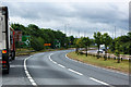
1

Rugby-Leicester Road
Looking down into the Swift Valley towards Lower Lodge Farm from the A426.
Image: © Ian Rob
Taken: 29 Nov 2007
0.20 miles
3
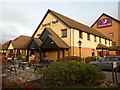
Rugby-Brewsters Inn
Attached to The Premier Travel Inn on Central Park right next to Junction 1 on the M6 Motorway.
Image: © Ian Rob
Taken: 12 Nov 2011
0.23 miles
4
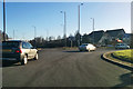
Rounding a roundabout on the A426
Central Park to the left, not the grass sort of park!
Image: © Robin Webster
Taken: 7 Jan 2018
0.23 miles