IMAGES TAKEN NEAR TO
Yelvertoft Road, RUGBY, CV23 0SY
Introduction
This page details the photographs taken nearby to Yelvertoft Road, CV23 0SY by members of the Geograph project.
The Geograph project started in 2005 with the aim of publishing, organising and preserving representative images for every square kilometre of Great Britain, Ireland and the Isle of Man.

There are currently over 7.5m images from over14,400 individuals and you can help contribute to the project by visiting https://www.geograph.org.uk
Image Map
Images are licensed for reuse under creativecommons.org/licenses/by-sa/2.0
Notes
- Clicking on the map will re-center to the selected point.
- The higher the marker number, the further away the image location is from the centre of the postcode.
Image Listing (41 Images Found)
Images are licensed for reuse under creativecommons.org/licenses/by-sa/2.0
Image
Details
Distance
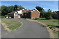
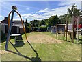
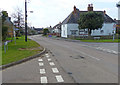
2

Lilbourne Village Hall
The Village Hall and Playing Field off Station Road.
Image: © Ian Rob
Taken: 23 Jan 2008
0.04 miles
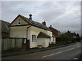
4
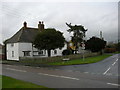
Lilbourne-The Old Manor House
On the corner of Station Road.
Image: © Ian Rob
Taken: 23 Jan 2008
0.05 miles
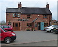
6
Lilbourne Old Schoolhouse
The converted School in Yelvertoft Road dates from 1873.
Image: © Ian Rob
Taken: 23 Jan 2008
0.06 miles
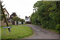
9
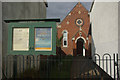
Lilbourne Evangelical Chapel
The chapel peeps round from behind another building, seen here from Chapel Lane.
Image: © Stephen McKay
Taken: 9 Oct 2011
0.09 miles