IMAGES TAKEN NEAR TO
Fosse Way, RUGBY, CV23 0RP
Introduction
This page details the photographs taken nearby to Fosse Way, CV23 0RP by members of the Geograph project.
The Geograph project started in 2005 with the aim of publishing, organising and preserving representative images for every square kilometre of Great Britain, Ireland and the Isle of Man.

There are currently over 7.5m images from over14,400 individuals and you can help contribute to the project by visiting https://www.geograph.org.uk
Image Map
Images are licensed for reuse under creativecommons.org/licenses/by-sa/2.0
Notes
- Clicking on the map will re-center to the selected point.
- The higher the marker number, the further away the image location is from the centre of the postcode.
Image Listing (8 Images Found)
Images are licensed for reuse under creativecommons.org/licenses/by-sa/2.0
Image
Details
Distance
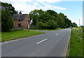
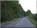
3
B4455 Fosse Way heading north
After a heavy rain shower.
Image: © Robin Webster
Taken: 11 Aug 2019
0.08 miles
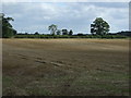
6
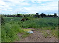
Farmland south of Cloudesley Bush
Looking east towards the woodland called Hobley Furze.
Image: © Mat Fascione
Taken: 5 Jun 2014
0.20 miles
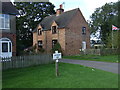
7
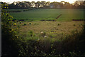
Farmland near Cloudesley Bush
Looking west from the Cloudesley Bush - Monks Kirby road towards buildings on the parallel Fosse Way, in fading evening light.
Image: © Stephen McKay
Taken: 11 May 2006
0.22 miles
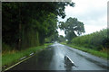
8
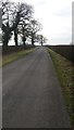
Minor Road leading to Monks Kirby
This minor road is captured on a cold winters day.
Image: © Peter Mackenzie
Taken: 6 Feb 2017
0.25 miles