IMAGES TAKEN NEAR TO
St. Denis View, RUGBY, CV23 0QS
Introduction
This page details the photographs taken nearby to St. Denis View, CV23 0QS by members of the Geograph project.
The Geograph project started in 2005 with the aim of publishing, organising and preserving representative images for every square kilometre of Great Britain, Ireland and the Isle of Man.

There are currently over 7.5m images from over14,400 individuals and you can help contribute to the project by visiting https://www.geograph.org.uk
Image Map
Images are licensed for reuse under creativecommons.org/licenses/by-sa/2.0
Notes
- Clicking on the map will re-center to the selected point.
- The higher the marker number, the further away the image location is from the centre of the postcode.
Image Listing (24 Images Found)
Images are licensed for reuse under creativecommons.org/licenses/by-sa/2.0
Image
Details
Distance
1
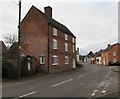
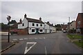
Pailton-Lutterworth Road
Looking toward the Village Centre.
Image: © Ian Rob
Taken: 2 Jan 2011
0.04 miles
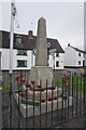
2
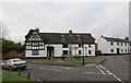
Pailton War Memorial
The War Memorial in front of Pailton Hall at the junction of Rugby, Coventry,and Lutterworth Roads.
Image: © Ian Rob
Taken: 2 Jan 2011
0.04 miles
3

Pailton War Memorial
The War Memorial is situated in the village centre.
Image: © Peter Mackenzie
Taken: 6 Mar 2017
0.05 miles
6
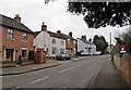
Pailton-Rugby Road
Cottages opposite the church.
Image: © Ian Rob
Taken: 2 Jan 2011
0.07 miles
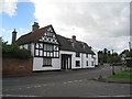
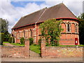
8
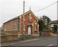
Pailton Village Hall
Originally the Reading Room dating from 1860.
Image: © Ian Rob
Taken: 2 Jan 2011
0.08 miles