IMAGES TAKEN NEAR TO
Brays Close, RUGBY, CV23 0NH
Introduction
This page details the photographs taken nearby to Brays Close, CV23 0NH by members of the Geograph project.
The Geograph project started in 2005 with the aim of publishing, organising and preserving representative images for every square kilometre of Great Britain, Ireland and the Isle of Man.

There are currently over 7.5m images from over14,400 individuals and you can help contribute to the project by visiting https://www.geograph.org.uk
Image Map
Images are licensed for reuse under creativecommons.org/licenses/by-sa/2.0
Notes
- Clicking on the map will re-center to the selected point.
- The higher the marker number, the further away the image location is from the centre of the postcode.
Image Listing (49 Images Found)
Images are licensed for reuse under creativecommons.org/licenses/by-sa/2.0
Image
Details
Distance
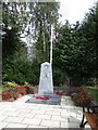
1
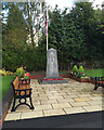
Brinklow War Memorial, at the corner of Broad Street and Coventry Road
Image: © Robin Stott
Taken: 6 Oct 2015
0.02 miles
2
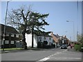
Brinklow-Coventry Road
Looking from the junction with Broad Street.
Image: © Ian Rob
Taken: 7 May 2008
0.02 miles
3
Brinklow-Broad Street
Near the junction with Rugby Road.
Image: © Ian Rob
Taken: 7 May 2008
0.03 miles
5
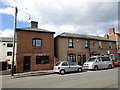
Houses in Brinklow
Nothing special architecturally but note the Flemish Bond on the left hand building using headers that have been slightly burnt to give a patterned effect.
Image: © Jonathan Thacker
Taken: 16 Sep 2016
0.03 miles
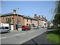
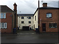
6

New housing in Coventry Road, Brinklow
These houses were completed not long before this photo was taken. They were built on the former site of the Dun Cow public house, which was demolished in 2002. A photo of the pub just before it was demolished (and taken from almost the same position as this one) can be found on the Closed Pubs website http://www.closedpubs.co.uk/warwickshire/brinklow_duncow.html
With so many pubs in Brinklow, it seemed at the time that it was almost inevitable that one would close. Thankfully all the others are still open at the time of writing.
Image: © John Brightley
Taken: 10 Jul 2004
0.04 miles
7
South on Coventry Way from Coventry Road, Brinklow
A Coventry Way is a 40-mile circular walk around Coventry: http://www.acoventryway.org.uk
Image: © Robin Stott
Taken: 6 Oct 2015
0.04 miles
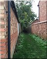
8
Set-back between properties, Broad Street, Brinklow
The building, centre, has the look of an old mill or factory. Perhaps it was a warehouse associated with the Oxford Canal before it was rerouted in the 19th century.
Image: © Robin Stott
Taken: 6 Oct 2015
0.04 miles
9
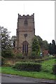
Brinklow Church
Dedicated to St. John the Baptist
Image: © Geoff Pick
Taken: 11 Feb 2006
0.05 miles
10

United Reformed Church, Broad Street, Brinklow
Image: © Robin Stott
Taken: 6 Oct 2015
0.05 miles