IMAGES TAKEN NEAR TO
Ansty Road, RUGBY, CV23 0NG
Introduction
This page details the photographs taken nearby to Ansty Road, CV23 0NG by members of the Geograph project.
The Geograph project started in 2005 with the aim of publishing, organising and preserving representative images for every square kilometre of Great Britain, Ireland and the Isle of Man.

There are currently over 7.5m images from over14,400 individuals and you can help contribute to the project by visiting https://www.geograph.org.uk
Image Map
Images are licensed for reuse under creativecommons.org/licenses/by-sa/2.0
Notes
- Clicking on the map will re-center to the selected point.
- The higher the marker number, the further away the image location is from the centre of the postcode.
Image Listing (5 Images Found)
Images are licensed for reuse under creativecommons.org/licenses/by-sa/2.0
Image
Details
Distance
1
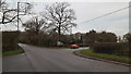
Rural road junction
The B4428 meets with the B4029 at this junction west of Brinklow.
Image: © Peter Mackenzie
Taken: 5 Dec 2017
0.04 miles
2
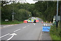
Police Road Closure
Police close the B4027 Coventry Road west of Brinklow after two aircraft collided killing five people
Image: © Adam Brookes
Taken: 17 Aug 2008
0.05 miles
3
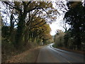
Coventry Road (B4428)
Looking east - direction Brinklow.
Image: © JThomas
Taken: 19 Nov 2016
0.14 miles
4
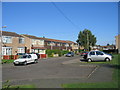
Brinklow
1970s housing off the main road on Brinklow.
Image: © David Stowell
Taken: 2 Sep 2005
0.18 miles