IMAGES TAKEN NEAR TO
Lutterworth Road, RUGBY, CV23 0LJ
Introduction
This page details the photographs taken nearby to Lutterworth Road, CV23 0LJ by members of the Geograph project.
The Geograph project started in 2005 with the aim of publishing, organising and preserving representative images for every square kilometre of Great Britain, Ireland and the Isle of Man.

There are currently over 7.5m images from over14,400 individuals and you can help contribute to the project by visiting https://www.geograph.org.uk
Image Map
Images are licensed for reuse under creativecommons.org/licenses/by-sa/2.0
Notes
- Clicking on the map will re-center to the selected point.
- The higher the marker number, the further away the image location is from the centre of the postcode.
Image Listing (43 Images Found)
Images are licensed for reuse under creativecommons.org/licenses/by-sa/2.0
Image
Details
Distance
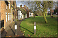
2
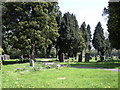
Brinklow Cemetery
The cemetery is at the northern edge of the Village.
Image: © Ian Rob
Taken: 7 May 2008
0.11 miles
3
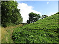
Footpath alongside the Motte. Brinklow
Image: © Jonathan Thacker
Taken: 16 Sep 2016
0.13 miles
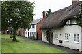
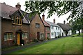
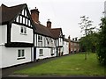
6
The Crescent, Brinklow
Possibly the most attractive part of the village, opposite the church.
Image: © Stephen McKay
Taken: 2 Dec 2007
0.15 miles
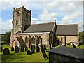
7
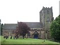
St. John the Baptist Church, Brinklow
Image: © Hugh Craddock
Taken: 28 May 2008
0.15 miles
9
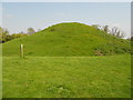
Brinklow Motte and Bailey
The remains of the Norman Castle.
Image: © Ian Rob
Taken: 22 May 2012
0.15 miles
10
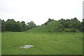
Brinklow Castle
This motte was put up in the early twelfth century. The photo is taken from a ditch which severs the bailey into two parts.
Image: © Hugh Craddock
Taken: 28 May 2008
0.16 miles