IMAGES TAKEN NEAR TO
Buckwell Lane, RUGBY, CV23 0BJ
Introduction
This page details the photographs taken nearby to Buckwell Lane, CV23 0BJ by members of the Geograph project.
The Geograph project started in 2005 with the aim of publishing, organising and preserving representative images for every square kilometre of Great Britain, Ireland and the Isle of Man.

There are currently over 7.5m images from over14,400 individuals and you can help contribute to the project by visiting https://www.geograph.org.uk
Image Map
Images are licensed for reuse under creativecommons.org/licenses/by-sa/2.0
Notes
- Clicking on the map will re-center to the selected point.
- The higher the marker number, the further away the image location is from the centre of the postcode.
Image Listing (12 Images Found)
Images are licensed for reuse under creativecommons.org/licenses/by-sa/2.0
Image
Details
Distance
1
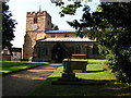
St Mary's
St Mary's Church, Clifton upon Dunsmore
Image: © David Reid
Taken: 17 Aug 2005
0.01 miles
2
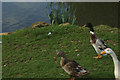
Ducks by Buckwell Lane
Three ducks make their presence felt beside the duckpond.
Image: © Stephen McKay
Taken: 16 Oct 2014
0.03 miles
3
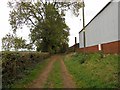
Clifton On Dunsmore-Buckwell Lane
Bridleway which is part of Shakespeare's Avon Way.
Image: © Ian Rob
Taken: 8 Oct 2011
0.06 miles
4
Clifton-On-Dunsmore-Buckwell Lane
Looking across to Manor Farm.
Image: © Ian Rob
Taken: 29 Nov 2007
0.07 miles
5
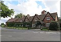
Clifton On Dunsmore-The Old Hall
Originally three cottages, now one dwelling.
Image: © Ian Rob
Taken: 7 Sep 2013
0.16 miles
6
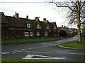
Clifton On Dunsmore
Looking towards the centre of the Village from the junction of Lilbourne Road and Hillmorton Lane.
Image: © Ian Rob
Taken: 22 Jan 2008
0.18 miles
7
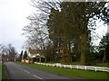
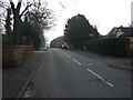
Clifton On Dunsmore
Hillmorton Lane near the Junction with South Road.
Image: © Ian Rob
Taken: 30 Jan 2008
0.20 miles
8
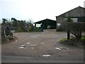
Clifton Hall Farm
On the road to Lilbourne.
Image: © Ian Rob
Taken: 30 Jan 2008
0.20 miles
9
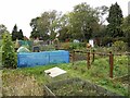
Clifton On Dunsmore Allotments
Looking from the cemetery.
Image: © Ian Rob
Taken: 8 Oct 2011
0.24 miles
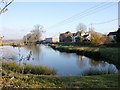
10
Main Street, Clifton upon Dunsmore
Heading east.
Image: © JThomas
Taken: 29 Mar 2014
0.24 miles