IMAGES TAKEN NEAR TO
Watling Street, RUGBY, CV23 0AL
Introduction
This page details the photographs taken nearby to Watling Street, CV23 0AL by members of the Geograph project.
The Geograph project started in 2005 with the aim of publishing, organising and preserving representative images for every square kilometre of Great Britain, Ireland and the Isle of Man.

There are currently over 7.5m images from over14,400 individuals and you can help contribute to the project by visiting https://www.geograph.org.uk
Image Map
Images are licensed for reuse under creativecommons.org/licenses/by-sa/2.0
Notes
- Clicking on the map will re-center to the selected point.
- The higher the marker number, the further away the image location is from the centre of the postcode.
Image Listing (18 Images Found)
Images are licensed for reuse under creativecommons.org/licenses/by-sa/2.0
Image
Details
Distance
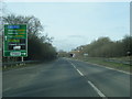
2

Europark, A5 near Clifton Upon Dunsmore
Industrial Park - signs at entrance - reminding drivers (twice) to only turn left in & out - the location is a black-spot for collisions on A5. Planning permission for improvements have been prepared as long as 2 years ago - still waiting for changes. Europark has a number of major companies on site, including Morgan Est and Balfour Beatty Utility Solutions.
Image: © Michael Westley
Taken: 26 Nov 2009
0.10 miles
3
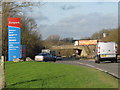
A5 Entrance to Europark, near M6
Taken from roadside, outside site of old petrol-station (opposite side of dual carriageway to bungalow), next to entrance to Europark. Bridge in background is M6 motorway, between Junction 1 and M1 interchange. Truck with orange trailer seen on motorway is heading north toward J1.
Image: © Michael Westley
Taken: 26 Nov 2009
0.11 miles
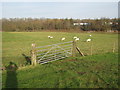
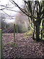
4
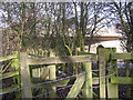
Gate and Footpath alongside M6, Watling Street
Alongside Europark on A5 Watling Street, and running parallel to M6 motorway (between J1 and Catthorpe interchange) there is a footpath / ROW that is accessed through this gate. The footpath runs toward Newton village and picnic site.
Image: © Michael Westley
Taken: 1 Dec 2009
0.11 miles
6
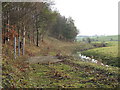
Right of Way, near Newton
Track and right of way running south around perimeter of Europark. Near to fence in photo is stile across stream that takes FP up and across the fields.
Image: © Michael Westley
Taken: 1 Dec 2009
0.12 miles
7
Field Footpath near Newton and Europark
Taken from field footpath half way up field heading for Newton, looking back toward Europark and M6 (in trees).
Image: © Michael Westley
Taken: 1 Dec 2009
0.13 miles
8
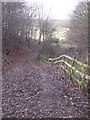
Right of way, near M6, A5 Watling Street
Right of way alongside M6 dips down to level of stream that runs north/south behind the industrial estate. Fields in background have footpaths and lead up to trackbed near Newton picnic site.
Image: © Michael Westley
Taken: 1 Dec 2009
0.13 miles
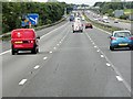
9
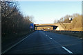
A5 heading north
The M6 crosses the bridge, with no junction.
Image: © Robin Webster
Taken: 7 Jan 2018
0.13 miles
10
Right of Way, M6 and A5 Watling Street
Where A5 crosses under M6 motorway, a Right of way runs west alongside the M6 and around the Europark industrial estate. As can be seen this is a narrow section of path, but runs all around to the west of site before running uphill across fields to Newton.
Image: © Michael Westley
Taken: 1 Dec 2009
0.14 miles