IMAGES TAKEN NEAR TO
Watling Street, RUGBY, CV23 0AG
Introduction
This page details the photographs taken nearby to Watling Street, CV23 0AG by members of the Geograph project.
The Geograph project started in 2005 with the aim of publishing, organising and preserving representative images for every square kilometre of Great Britain, Ireland and the Isle of Man.

There are currently over 7.5m images from over14,400 individuals and you can help contribute to the project by visiting https://www.geograph.org.uk
Image Map
Images are licensed for reuse under creativecommons.org/licenses/by-sa/2.0
Notes
- Clicking on the map will re-center to the selected point.
- The higher the marker number, the further away the image location is from the centre of the postcode.
Image Listing (6 Images Found)
Images are licensed for reuse under creativecommons.org/licenses/by-sa/2.0
Image
Details
Distance
1
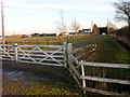
Lilbourne-The Meadows
Just off the track which runs between Hillmorton locks and Watling Street.
Image: © Ian Rob
Taken: 10 Feb 2008
0.07 miles
2
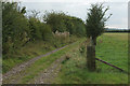
Track to Hillmorton
The start of a rougher section of the track from the gateway to The Meadows.
Image: © Stephen McKay
Taken: 14 Sep 2014
0.10 miles
3
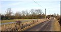
Lilbourne
The road from Hillmorton Locks near the junction with Watling Street.
Image: © Ian Rob
Taken: 10 Feb 2008
0.13 miles
4
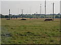
Masts anchor bases.
Apparently all the masts are Rugby Radio Station are to be removed eventually. These concrete bases held the support cables for one of the large masts that has already been removed.
Image: © David Reid
Taken: 17 Aug 2005
0.15 miles
5
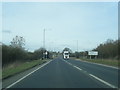
A5 northbound at the Warwickshire county boundary
Image: © Colin Pyle
Taken: 29 Feb 2016
0.22 miles
6
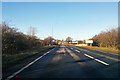
A5 heading north
Crossing from Northamptonshire to Warwickshire according to the signs, but the mapped boundary seems to run down the middle of the road for some considerable distance, so this direction is Warwickshire, the other Northamptonshire.
Image: © Robin Webster
Taken: 7 Jan 2018
0.24 miles