IMAGES TAKEN NEAR TO
Wavendon Close, COVENTRY, CV2 2TJ
Introduction
This page details the photographs taken nearby to Wavendon Close, CV2 2TJ by members of the Geograph project.
The Geograph project started in 2005 with the aim of publishing, organising and preserving representative images for every square kilometre of Great Britain, Ireland and the Isle of Man.

There are currently over 7.5m images from over14,400 individuals and you can help contribute to the project by visiting https://www.geograph.org.uk
Image Map
Images are licensed for reuse under creativecommons.org/licenses/by-sa/2.0
Notes
- Clicking on the map will re-center to the selected point.
- The higher the marker number, the further away the image location is from the centre of the postcode.
Image Listing (15 Images Found)
Images are licensed for reuse under creativecommons.org/licenses/by-sa/2.0
Image
Details
Distance
4
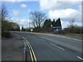
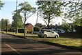
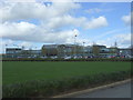
Coventry-Potter's Green
Woodway Medical Centre on the right and Ringwood pharmacy on the left.
Image: © Ian Rob
Taken: 16 May 2012
0.14 miles
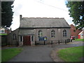
6
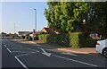
United Reformed Church Hall, Potter's Green
Image: © Jonathan Thacker
Taken: 29 Aug 2010
0.15 miles
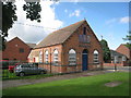
7
United Reformed Church, Potter's Green
Image: © Jonathan Thacker
Taken: 29 Aug 2010
0.16 miles
8
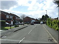
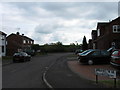
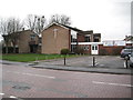
Brookshaw Way, Woodway Park
Looking south west.
Image: © JThomas
Taken: 4 Mar 2017
0.19 miles
10
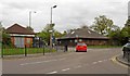
Coventry: St Philip's Church, Potter's Green
St Philip's Church is on the Ringwood Highway opposite Image
Image: © Nigel Cox
Taken: 31 Dec 2011
0.20 miles