IMAGES TAKEN NEAR TO
Hemingford Road, COVENTRY, CV2 2RE
Introduction
This page details the photographs taken nearby to Hemingford Road, CV2 2RE by members of the Geograph project.
The Geograph project started in 2005 with the aim of publishing, organising and preserving representative images for every square kilometre of Great Britain, Ireland and the Isle of Man.

There are currently over 7.5m images from over14,400 individuals and you can help contribute to the project by visiting https://www.geograph.org.uk
Image Map
Images are licensed for reuse under creativecommons.org/licenses/by-sa/2.0
Notes
- Clicking on the map will re-center to the selected point.
- The higher the marker number, the further away the image location is from the centre of the postcode.
Image Listing (9 Images Found)
Images are licensed for reuse under creativecommons.org/licenses/by-sa/2.0
Image
Details
Distance
1
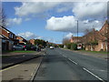
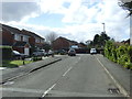
Wigston Road, Woodway Park
Looking north west.
Image: © JThomas
Taken: 4 Mar 2017
0.07 miles
2
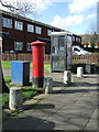
Elizabeth II postbox and telephone box on Wigston Road
Postbox No. CV2 314.
See Image] for postbox.
Image: © JThomas
Taken: 4 Mar 2017
0.08 miles
3
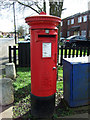
Elizabeth II postbox on Wigston Road
Postbox No. CV2 314.
See Image] for context.
Image: © JThomas
Taken: 4 Mar 2017
0.08 miles
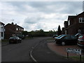
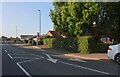
5
Brookshaw Way, Woodway Park
Looking south west.
Image: © JThomas
Taken: 4 Mar 2017
0.11 miles
7
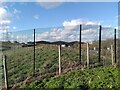
Denso, formerly Alvis, Walsgrave Triangle, Coventry
Behind the fence stand the premises of Denso, a Japanese automotive parts manufacturer. Before Denso moved in, this was where Alvis plc built armoured vehicles, from 1990 to 1999, when production was moved to Telford. Alvis eventually became part of BAe Systems in 2004. The Alvis name and red triangle marque were acquired by the company in Kenilworth which provides parts and servicing for historic Alvis motor cars, and now builds modern versions of them; see Image], also Grace's Guide to British Industrial History on Alvis https://www.gracesguide.co.uk/Alvis .
Like most armaments companies, Alvis was sometimes controversial; armoured vehicles made here were supplied to the Suharto military regime in Indonesia, and from 1997 to 1998 a peace camp protested outside the factory. The camp was situated on the Walsgrave Triangle side of the factory, by the road; see the Coventry Peace House site https://coventrypeacehouse.wixsite.com/coventry-peace-house/about_us .
Image: © A J Paxton
Taken: 25 Mar 2023
0.19 miles
8
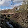
Country park footbridge, Walsgrave-on-Sowe
This footbridge crosses a stream, unnamed on the OS map, that rises near Shilton Lane, just outside Coventry, and flows into the River Sowe near the hospital. The bridge carries a footpath through the public open space that separates the suburb of Woodway Park from the Walsgrave Triangle business park.
Image: © A J Paxton
Taken: 25 Mar 2023
0.20 miles
9
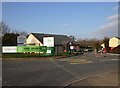
Campanile Hotel & Restaurant, Wigston Road, Coventry
Looking north from Wigston Road, near the roundabout on the A4600.
Image: © David P Howard
Taken: 11 Mar 2010
0.25 miles