IMAGES TAKEN NEAR TO
Manfield Avenue, COVENTRY, CV2 2QF
Introduction
This page details the photographs taken nearby to Manfield Avenue, CV2 2QF by members of the Geograph project.
The Geograph project started in 2005 with the aim of publishing, organising and preserving representative images for every square kilometre of Great Britain, Ireland and the Isle of Man.

There are currently over 7.5m images from over14,400 individuals and you can help contribute to the project by visiting https://www.geograph.org.uk
Image Map
Images are licensed for reuse under creativecommons.org/licenses/by-sa/2.0
Notes
- Clicking on the map will re-center to the selected point.
- The higher the marker number, the further away the image location is from the centre of the postcode.
Image Listing (32 Images Found)
Images are licensed for reuse under creativecommons.org/licenses/by-sa/2.0
Image
Details
Distance
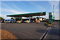
2
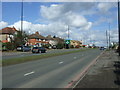
Hinckley Road, Walsgrave on Sowe
Looking north east on the A4600.
Image: © JThomas
Taken: 4 Mar 2017
0.13 miles
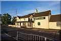
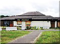
8

The Mount Pleasant, Walsgrave on Sowe
A hungry horse public house on Hinckley Road.
Image: © JThomas
Taken: 4 Mar 2017
0.17 miles
9

Coventry-Mount Pleasant Public House
The name appearing to refer to the local area.
Image: © Ian Rob
Taken: 16 May 2012
0.17 miles