IMAGES TAKEN NEAR TO
Darrach Close, COVENTRY, CV2 2GL
Introduction
This page details the photographs taken nearby to Darrach Close, CV2 2GL by members of the Geograph project.
The Geograph project started in 2005 with the aim of publishing, organising and preserving representative images for every square kilometre of Great Britain, Ireland and the Isle of Man.

There are currently over 7.5m images from over14,400 individuals and you can help contribute to the project by visiting https://www.geograph.org.uk
Image Map
Images are licensed for reuse under creativecommons.org/licenses/by-sa/2.0
Notes
- Clicking on the map will re-center to the selected point.
- The higher the marker number, the further away the image location is from the centre of the postcode.
Image Listing (16 Images Found)
Images are licensed for reuse under creativecommons.org/licenses/by-sa/2.0
Image
Details
Distance
1
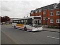
Coventry-Potter's Green
Bus on Ringwood Highway is a Hospital Circular Service 704 serving Potter's Green and Wood End.
Image: © Ian Rob
Taken: 16 May 2012
0.06 miles
2
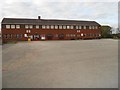
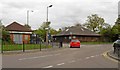
Coventry-Potters Green School
Primary School on Ringwood Highway.
Image: © Ian Rob
Taken: 16 May 2012
0.08 miles
3
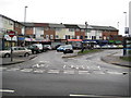
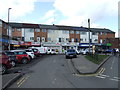
Coventry: Potter's Green shops
These local shops with maisonettes above are at the junction of Yewdale Crescent with the Ringwood Highway.
Image: © Nigel Cox
Taken: 31 Dec 2011
0.09 miles
4
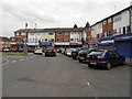
Coventry-Potter's Green Shops
At the junction of Yewdale Crescent and the Ringwood Highway.
Image: © Ian Rob
Taken: 16 May 2012
0.09 miles
5
Shops off Ringwood Highway
Includes a Post Office.
Image: © JThomas
Taken: 4 Mar 2017
0.09 miles
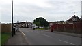
6
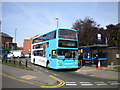
Bus at Potters Green terminus
After many years of use by route 32 from Tile Hill via Coventry city centre, since a major network revision in February 2012 buses have not used this terminus. The terminus is not a turning circle as such, being combined cleverly with a service road that serves a parade of shops (see Image), and was still very much in use when this view was taken.
Image: © Richard Vince
Taken: 4 Oct 2011
0.10 miles
7
Coventry: St Philip's Church, Potter's Green
St Philip's Church is on the Ringwood Highway opposite Image
Image: © Nigel Cox
Taken: 31 Dec 2011
0.12 miles
9
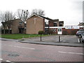
Coventry-Potter's Green
Woodway Medical Centre on the right and Ringwood pharmacy on the left.
Image: © Ian Rob
Taken: 16 May 2012
0.18 miles
10
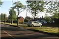
Waiting for the bus
Ringwood Highway in Potter's Green on the northern edge of the city of Coventry.
Image: © Peter Mackenzie
Taken: 27 Jul 2017
0.18 miles