IMAGES TAKEN NEAR TO
Beswick Gardens, RUGBY, CV22 7PR
Introduction
This page details the photographs taken nearby to Beswick Gardens, CV22 7PR by members of the Geograph project.
The Geograph project started in 2005 with the aim of publishing, organising and preserving representative images for every square kilometre of Great Britain, Ireland and the Isle of Man.

There are currently over 7.5m images from over14,400 individuals and you can help contribute to the project by visiting https://www.geograph.org.uk
Image Map
Images are licensed for reuse under creativecommons.org/licenses/by-sa/2.0
Notes
- Clicking on the map will re-center to the selected point.
- The higher the marker number, the further away the image location is from the centre of the postcode.
Image Listing (33 Images Found)
Images are licensed for reuse under creativecommons.org/licenses/by-sa/2.0
Image
Details
Distance
1

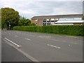
Bilton-Beswick Gardens
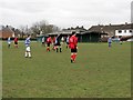
Beswick Gardens was built in the 1960s on the site of the Longrood School for Boys. There is a footpath through to the playing field.
Image: © Ian Rob
Taken: 18 Apr 2010
0.07 miles
2

Rugby - Bilton
Rugby High School for Girls, Longrood Road.
Image: © Ian Rob
Taken: 20 Aug 2005
0.11 miles
3
Rugby High School for Girls
On Longrood Road Bilton.
Image: © Ian Rob
Taken: 10 May 2009
0.11 miles
4
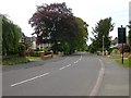
Bilton-Longrood Road
Approaching Bawnmore Road.
Image: © Ian Rob
Taken: 10 May 2009
0.13 miles
5
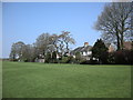
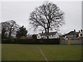
Alwyn Road Playing Field
Houses in Hampden Way back on to the playing field.
Image: © Ian Rob
Taken: 18 Apr 2010
0.13 miles
6
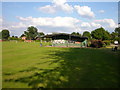
Old Bilton-Alwyn Road.
The changing rooms at the Playing Field.
Image: © Ian Rob
Taken: 16 Jun 2008
0.13 miles
9

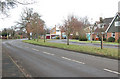
Cymbeline Way, Bilton
Houses built in the period when large 'picture windows' were fashionable.
Image: © Stephen McKay
Taken: 12 Oct 2008
0.14 miles
10
Bilton-Alwyn Road Recreation Ground
Houses in Hampden Way.
Image: © Ian Rob
Taken: 13 Apr 2013
0.15 miles