IMAGES TAKEN NEAR TO
Upton Road, RUGBY, CV22 7DL
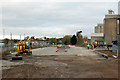
Introduction
This page details the photographs taken nearby to Upton Road, CV22 7DL by members of the Geograph project.
The Geograph project started in 2005 with the aim of publishing, organising and preserving representative images for every square kilometre of Great Britain, Ireland and the Isle of Man.

There are currently over 7.5m images from over14,400 individuals and you can help contribute to the project by visiting https://www.geograph.org.uk
Image Map
Images are licensed for reuse under creativecommons.org/licenses/by-sa/2.0
Notes
- Clicking on the map will re-center to the selected point.
- The higher the marker number, the further away the image location is from the centre of the postcode.
Image Listing (104 Images Found)
Images are licensed for reuse under creativecommons.org/licenses/by-sa/2.0
Image
Details
Distance
1
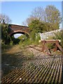
Rugby-New Bilton
The End of the Line. The Rugby-Leamington line stops here south west of the Lawford Road bridge.
Image: © Ian Rob
Taken: 22 Apr 2007
0.02 miles
2
New Bilton-Lawford Road bridge
Groundwork continues for the Western Relief Road around the course of the Leamington-Rugby Line.
Image: © Ian Rob
Taken: 7 Oct 2008
0.02 miles
3
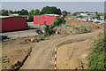
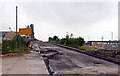
New road construction, New Bilton
Looking from the former railway bridge that carried Lawford Road over the Rugby - Leamington railway, this view follows the railway's route and shows the work taking place to construct Rugby's Western Relief Road. The factory units on the left are part of the Somers Road industrial estate.
Image: © Stephen McKay
Taken: 27 Jul 2008
0.02 miles
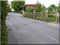
4
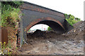
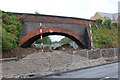
Lawford Road railway bridge blocked (2)
The Rugby western bypass road is due to open in late 2009. It follows, and in some places is built over, the dismantled railway that ran from Rugby to Leamington Spa. This bridge carried Lawford Road over the railway until spring 2009 when Lawford Road was diverted. This view is looking southwest. For a view of this location before construction of the bypass see [http://www.geograph.org.uk/photo/409625] .
Image: © Andy F
Taken: 7 Jun 2009
0.02 miles
5
Roadworks progressing on Lawford Road, Rugby
Looking west at roadworks for Rugby's Western Relief Road at Lawford Road. Compare progress with the same location a month earlier [http://www.geograph.org.uk/photo/1493514] .
Image: © Andy F
Taken: 26 Oct 2009
0.04 miles
6
Rugby western bypass construction (11)
The Rugby western bypass road is due to open in late 2009. This is a view of the former course of Lawford Road looking east: the road used to cross a railway bridge at the top of this the slope but has now been diverted a 50 metres south (to the right of the photo).
Image: © Andy F
Taken: 7 Jun 2009
0.04 miles
7
Rugby - New Bilton
Gates of the disused Level Crossing in Parkfield Road which linked the Rugby- Leamington line with the Cement Works.
Image: © Ian Rob
Taken: 28 May 2006
0.05 miles
8

New Bilton-Lawford Road
New housing development at the site of a former scrapyard. Close to the Cement Works and a junction of the new Rugby By-pass, not such a great position!
Image: © Ian Rob
Taken: 7 May 2008
0.05 miles
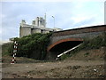
9
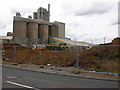
Rugby Cement Works
A clearer view of the works after the removal of the 150 year old bridge over the dismantled Rugby-Leamington line.Image]
Image: © Ian Rob
Taken: 11 Jul 2009
0.05 miles
10
Lawford Road railway bridge blocked
The Rugby western bypass road is due to open in late 2009. It follows, and in some places is built over, the dismantled railway that ran from Rugby to Leamington Spa. This bridge carried Lawford Road over the railway until spring 2009 when Lawford Road was diverted. This view is looking northeast with the new course of Lawford road in the foreground.
Image: © Andy F
Taken: 7 Jun 2009
0.05 miles