IMAGES TAKEN NEAR TO
Vicarage Lane, RUGBY, CV22 6QR
Introduction
This page details the photographs taken nearby to Vicarage Lane, CV22 6QR by members of the Geograph project.
The Geograph project started in 2005 with the aim of publishing, organising and preserving representative images for every square kilometre of Great Britain, Ireland and the Isle of Man.

There are currently over 7.5m images from over14,400 individuals and you can help contribute to the project by visiting https://www.geograph.org.uk
Image Map
Images are licensed for reuse under creativecommons.org/licenses/by-sa/2.0
Notes
- Clicking on the map will re-center to the selected point.
- The higher the marker number, the further away the image location is from the centre of the postcode.
Image Listing (6 Images Found)
Images are licensed for reuse under creativecommons.org/licenses/by-sa/2.0
Image
Details
Distance
1
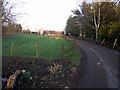
Dunchurch Lodge Farm
The lane leading to the farm.
Image: © Ian Rob
Taken: 28 Dec 2011
0.05 miles
2
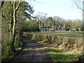
Dunchurch Lodge
Cottages in the Grounds of Bilton Grange.
Image: © Ian Rob
Taken: 29 Dec 2007
0.13 miles
3
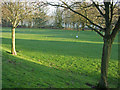
The grounds - Dunchurch Park Hotel
Dunchurch Park Hotel is set in 72 acres of grounds, including this putting green for the use of guests.
Image: © Stephen McKay
Taken: 9 Jan 2013
0.20 miles
4
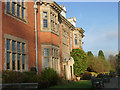
Dunchurch Park Hotel
This shows part of the original grade II listed manor house, although the building has been extended considerably.
Image: © Stephen McKay
Taken: 9 Jan 2013
0.24 miles
5
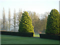
The gardens - Dunchurch Park Hotel
Part of the 72 acres of grounds and gardens that surround the hotel seen on a bright but slightly misty winter's day.
Image: © Stephen McKay
Taken: 9 Jan 2013
0.24 miles
6
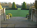
The gardens - Dunchurch Park Hotel
Seen from the terrace, the gardens fall away to the lake at this attractive venue.
Image: © Stephen McKay
Taken: 9 Jan 2013
0.24 miles