IMAGES TAKEN NEAR TO
Norton Leys, RUGBY, CV22 5RS
Introduction
This page details the photographs taken nearby to Norton Leys, CV22 5RS by members of the Geograph project.
The Geograph project started in 2005 with the aim of publishing, organising and preserving representative images for every square kilometre of Great Britain, Ireland and the Isle of Man.

There are currently over 7.5m images from over14,400 individuals and you can help contribute to the project by visiting https://www.geograph.org.uk
Image Map
Images are licensed for reuse under creativecommons.org/licenses/by-sa/2.0
Notes
- Clicking on the map will re-center to the selected point.
- The higher the marker number, the further away the image location is from the centre of the postcode.
Image Listing (15 Images Found)
Images are licensed for reuse under creativecommons.org/licenses/by-sa/2.0
Image
Details
Distance
1
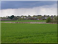
Bilton Fields
Rain Falling in the distance.
Image: © Ian Rob
Taken: 25 Apr 2010
0.07 miles
2
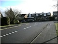
Rugby-Goldsmith Avenue.
The small parade of shops is in Norton Leys.
Image: © Ian Rob
Taken: 17 Jan 2010
0.15 miles
4
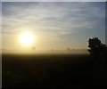
Bilton Fields Sunrise
Big sun rising behind the water tower.
Image: © Ian Rob
Taken: 2 Jun 2011
0.18 miles
5
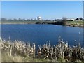
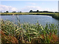
Rugby-Bilton Fields
Pool near Martin's Farm. Land likely to be developed for housing.
Image: © Ian Rob
Taken: 9 Mar 2014
0.19 miles
6
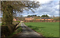
Bilton Fields Farm
More of a housing development than a farm.
Image: © Robert Eva
Taken: 21 Mar 2017
0.19 miles
7
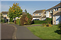
Orson Leys, Hillside
Immaculately kept front gardens on this quiet estate to the south of Rugby town centre.
Image: © Stephen McKay
Taken: 12 Oct 2008
0.19 miles
8
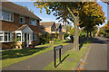
Drayton Leys, Hillside
Seen from the junction with Orson Leys.
Image: © Stephen McKay
Taken: 12 Oct 2008
0.21 miles
9
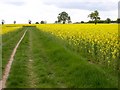
Rugby -Ashlawn Road
Bridleway through the rapeseed.
Image: © Ian Rob
Taken: 10 May 2009
0.22 miles
10
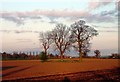
Rugby - Bilton Fields
Setting sun shines on freshly ploughed field at Bilton Fields Farm.
Image: © Ian Rob
Taken: 25 Apr 2006
0.22 miles