IMAGES TAKEN NEAR TO
White Oak Close, RUGBY, CV22 5FT
Introduction
This page details the photographs taken nearby to White Oak Close, CV22 5FT by members of the Geograph project.
The Geograph project started in 2005 with the aim of publishing, organising and preserving representative images for every square kilometre of Great Britain, Ireland and the Isle of Man.

There are currently over 7.5m images from over14,400 individuals and you can help contribute to the project by visiting https://www.geograph.org.uk
Image Map
Images are licensed for reuse under creativecommons.org/licenses/by-sa/2.0
Notes
- Clicking on the map will re-center to the selected point.
- The higher the marker number, the further away the image location is from the centre of the postcode.
Image Listing (29 Images Found)
Images are licensed for reuse under creativecommons.org/licenses/by-sa/2.0
Image
Details
Distance
2
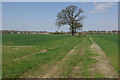
Bridleway to Hillside Estate
This bridleway leads across fields from Ashlawn Road to Norton Leys on the Hillside Estate - whose houses can be seen in the distance.
Image: © Stephen McKay
Taken: 21 Apr 2010
0.07 miles
3
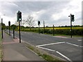
Rugby-Ashlawn Road
A Pegasus crossing for pedestrians and cyclists, and mounted horse riders connecting two bridlepaths across a busy road. www.geograph.org.uk/photo/1818976
Image: © Ian Rob
Taken: 10 May 2009
0.08 miles
4
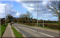
Road crossing for the footpath
A pelican crossing over Ashlawn Road for the footpath leading back into Rugby.
Image: © Robert Eva
Taken: 21 Mar 2017
0.09 miles
5
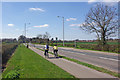
Pegasus crossing, Ashlawn Road
This could well be a contender for the most rurally located light-controlled pedestrian crossing in the country. Many people have questioned the need for this facility and, by coincidence, a letter appeared in a local newspaper the day after this photograph was taken in which the writer claimed never to have seen anyone using it despite driving this way regularly. The crossing does link a bridleway with the cycle path on the south side of the road and was justified as part of a 'safer route to schools' initiative to encourage pupils at Ashlawn School to walk or cycle this way from the Hillside Estate.
Image: © Stephen McKay
Taken: 21 Apr 2010
0.10 miles
6
Rugby-Martins Farm
View from the Bridleway.
Image: © Ian Rob
Taken: 25 Apr 2010
0.10 miles
7
Footpath towards Onley
A path leading south from Ashlawn Road
Image: © Robert Eva
Taken: 21 Mar 2017
0.10 miles
8
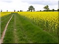
Rugby -Ashlawn Road
Bridleway through the rapeseed.
Image: © Ian Rob
Taken: 10 May 2009
0.10 miles
9
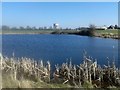
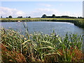
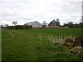
Rugby-Bilton Fields
Pool near Martin's Farm. Land likely to be developed for housing.
Image: © Ian Rob
Taken: 9 Mar 2014
0.11 miles
10
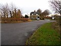
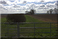
Rugby-Ashlawn Road
House at the entrance to Inwoods Farm.
Image: © Ian Rob
Taken: 31 Dec 2011
0.14 miles