IMAGES TAKEN NEAR TO
Sledmere Close, COVENTRY, CV2 1RF
Introduction
This page details the photographs taken nearby to Sledmere Close, CV2 1RF by members of the Geograph project.
The Geograph project started in 2005 with the aim of publishing, organising and preserving representative images for every square kilometre of Great Britain, Ireland and the Isle of Man.

There are currently over 7.5m images from over14,400 individuals and you can help contribute to the project by visiting https://www.geograph.org.uk
Image Map
Images are licensed for reuse under creativecommons.org/licenses/by-sa/2.0
Notes
- Clicking on the map will re-center to the selected point.
- The higher the marker number, the further away the image location is from the centre of the postcode.
Image Listing (14 Images Found)
Images are licensed for reuse under creativecommons.org/licenses/by-sa/2.0
Image
Details
Distance
1

Alderman's Green Jubilee Hall
Built in 1908 according to inscription in the stonework around the doorway.
Image: © David Stowell
Taken: 30 Aug 2006
0.09 miles
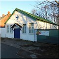
2

Alderman's Green Free Methodist Church
Situated next to the Jubilee Hall in Alderman's Green Road.
Image: © David Stowell
Taken: 30 Aug 2006
0.09 miles
3

The Bird in Hand, Alderman's Green
Situated in Alderman's Green Road almost opposite the Free Methodist Church.
Image: © David Stowell
Taken: 30 Aug 2006
0.09 miles
4

Co-operative Street
This street of houses off Alderman's Green Road was built shortly before the First World War by the Coventry Perseverance Co-operative Society. See Fry, D & Smith A, The Coventry we have lost: Forgotten Foleshill, Simanda Press, 2018.
Image: © A J Paxton
Taken: 11 Nov 2022
0.10 miles
5
Scouts & slimmers
This is the hut of the 82nd Coventry Scout Group on Alderman's Green Road.
Image: © A J Paxton
Taken: 26 Dec 2022
0.15 miles
6

Wyken Pool in winter
This is a view of Wyken Pool on Boxing Day 2022, seen from the eastern shore looking towards Alderman's Green School among the trees to the west. The pool is a flash caused by coal mining subsidence in the 19th century. It is Coventry's largest body of water, much appreciated by water birds and by local people.
Image: © A J Paxton
Taken: 26 Dec 2022
0.15 miles
7
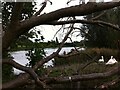
Swans by Wyken Pool
For more on Wyken Pool, a creation of 19th century coal mining subsidence, see Image
Image: © A J Paxton
Taken: 11 Sep 2022
0.16 miles
8

Earth's eye: Wyken Pool, Coventry
"A lake is the landscape's most beautiful and expressive feature. It is earth's eye; looking into which the beholder measures the depth of his own nature." Henry Thoreau, 'Walden' (see 'Walden' at Project Gutenberg https://www.gutenberg.org/files/205/205-h/205-h.htm ).
Perhaps that's true even when the lake is the result of subsidence caused by coal mining, as at Wyken Pool in Coventry. Perhaps even when the lake is sandwiched between the roaring M6 motorway Image] and some of the city's most deprived neighbourhoods Image
Image: © A J Paxton
Taken: 26 Dec 2022
0.17 miles
9

Wyken Pool
Wyken Pool is the largest body of standing water in Coventry and came into existence around 1860. It is a flash, a pond created by mining subsidence, in this case presumably the work of the Craven colliery in Wyken. https://www.coventrysociety.org.uk/coventry-neighbourhoods/wyken.html To the north is Wyken Slough, a nature reserve which attracts wintering birds. https://www.warwickshirewildlifetrust.org.uk/WykenSlough
Image: © A J Paxton
Taken: 28 Sep 2009
0.18 miles
10
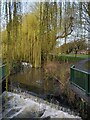
Weir and willows on the River Sowe, Longford Park
A footbridge crosses the river just below a weir. Longford Park occupies the floodplain of the Sowe, and the course of the river has been much altered here, so that through the eastern side of the park it follows neither its historic course nor that of the mill course that supplied Foleshill Mill Image A 'weeping' cultivar of the Chinese willow Salix babylonica has been planted to create an attractive riverside walk; see Image
Image: © A J Paxton
Taken: 22 Mar 2023
0.19 miles