IMAGES TAKEN NEAR TO
Silverdale Close, COVENTRY, CV2 1QD
Introduction
This page details the photographs taken nearby to Silverdale Close, CV2 1QD by members of the Geograph project.
The Geograph project started in 2005 with the aim of publishing, organising and preserving representative images for every square kilometre of Great Britain, Ireland and the Isle of Man.

There are currently over 7.5m images from over14,400 individuals and you can help contribute to the project by visiting https://www.geograph.org.uk
Image Map
Images are licensed for reuse under creativecommons.org/licenses/by-sa/2.0
Notes
- Clicking on the map will re-center to the selected point.
- The higher the marker number, the further away the image location is from the centre of the postcode.
Image Listing (8 Images Found)
Images are licensed for reuse under creativecommons.org/licenses/by-sa/2.0
Image
Details
Distance
1
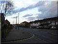
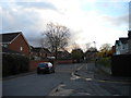
Grange Road, Alderman's Green
Looking north towards Victoria Farm estate from the junction with Hurst Road.
Image: © Richard Vince
Taken: 10 Nov 2012
0.09 miles
2
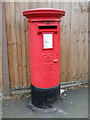
Elizabeth II postbox on Grange Road
Postbox No. CV6 110.
See Image] for context.
Image: © JThomas
Taken: 4 Mar 2017
0.13 miles
3
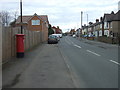
Grange Road
Showing position of Postbox No. CV6 110.
See Image] for postbox.
Image: © JThomas
Taken: 4 Mar 2017
0.13 miles
4
Longford Park, Coventry
View looking towards the City.
Image: © Peterson Cobbett
Taken: 30 Aug 2003
0.20 miles
5
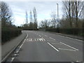
Hurst Road, Longford
Hurst Road is divided into two sections for vehicular traffic by a fence that is not all that easy to see in feeble light of an early evening in November. There appear to be several decades between the houses on the two sides of the road.
Image: © Richard Vince
Taken: 10 Nov 2012
0.21 miles
7
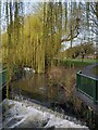
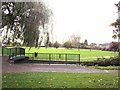
Weir and willows on the River Sowe, Longford Park
A footbridge crosses the river just below a weir. Longford Park occupies the floodplain of the Sowe, and the course of the river has been much altered here, so that through the eastern side of the park it follows neither its historic course nor that of the mill course that supplied Foleshill Mill Image A 'weeping' cultivar of the Chinese willow Salix babylonica has been planted to create an attractive riverside walk; see Image
Image: © A J Paxton
Taken: 22 Mar 2023
0.22 miles
8
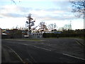
Turning circle on Ansell Drive, Victoria Farm
Although it does not appear to contain a bus stop, it appears possible that this turning circle may be used by school buses to Foxford School, outside whose entrance it is located.
Image: © Richard Vince
Taken: 10 Nov 2012
0.24 miles