
IMAGES TAKEN NEAR TO
Coventry Road, COVENTRY, CV2 1NU
Introduction
This page details the photographs taken nearby to Coventry Road, CV2 1NU by members of the Geograph project.
The Geograph project started in 2005 with the aim of publishing, organising and preserving representative images for every square kilometre of Great Britain, Ireland and the Isle of Man.

There are currently over 7.5m images from over14,400 individuals and you can help contribute to the project by visiting https://www.geograph.org.uk
Image Map
Images are licensed for reuse under creativecommons.org/licenses/by-sa/2.0
Notes
- Clicking on the map will re-center to the selected point.
- The higher the marker number, the further away the image location is from the centre of the postcode.
Image Listing (2 Images Found)
Images are licensed for reuse under creativecommons.org/licenses/by-sa/2.0
Image
Details
Distance
1
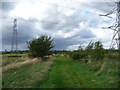
Part of the Coventry Way approaching the Centenary Way
Beneath pylons the Way approaches a link-up with the Centenary Way alongside the Coventry Canal on the outskirts of Bedworth.
Image: © Jeremy Bolwell
Taken: 28 Aug 2009
0.18 miles
2
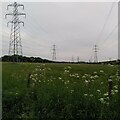
Cutting a swathe through Sweet Laud's Wood
A strip about 150m wide has been cleared of trees to make way for these three power lines, which join a significant node of the National Grid at the site of the former coal fired power station at Hawkesbury. They are viewed here from a footpath that forms part of the Coventry Way.
Image: © A J Paxton
Taken: 30 May 2023
0.23 miles