
IMAGES TAKEN NEAR TO
Pine Grove, RUGBY, CV21 4BL
Introduction
This page details the photographs taken nearby to Pine Grove, CV21 4BL by members of the Geograph project.
The Geograph project started in 2005 with the aim of publishing, organising and preserving representative images for every square kilometre of Great Britain, Ireland and the Isle of Man.

There are currently over 7.5m images from over14,400 individuals and you can help contribute to the project by visiting https://www.geograph.org.uk
Image Map
Images are licensed for reuse under creativecommons.org/licenses/by-sa/2.0
Notes
- Clicking on the map will re-center to the selected point.
- The higher the marker number, the further away the image location is from the centre of the postcode.
Image Listing (97 Images Found)
Images are licensed for reuse under creativecommons.org/licenses/by-sa/2.0
Image
Details
Distance
1
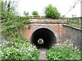
Hillmorton Footpath
Footpath under the West Coast Mainline to Saint John the Baptist Church and The Locks on the Oxford Canal.
Image: © Ian Rob
Taken: 24 Apr 2011
0.03 miles
2
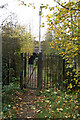
The path is narrow....
Already partly cut off by the canal built to the north, St John's church was isolated from its growing community by the building of the London-Glasgow railway. A single track road to the east allows access for vehicles, while this footpath gives more direct pedestrian access between the church and its housing.
Image: © David Long
Taken: 29 Oct 2009
0.06 miles
3
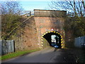
Hillmorton-Brindley Road
Bridge under the West Coast Mainline to The Locks. A footpath to the church goes under a nearby bridge.
Image: © Ian Rob
Taken: 10 Feb 2008
0.07 miles
4
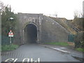
Railway Viaduct, Hillmorton, Rugby
Single track road under main Rugby - London railway line. Road goes between housing area of Hillmorton and the Oxford Canal locks.
Compare this to Image] the other end of tunnel - notice how the height is different? Half-way through the tunnel there's a further height restriction notice warning the roof gets lower!
Not to worry though, because unless you've gone 'cross country' past the radio station Image], you'd have had to come through from the other side first - so any double-deckers would have been crushed then, lol :)
Image: © Michael Westley
Taken: 17 Dec 2009
0.09 miles
5
Hillmorton-West Coast Mainline
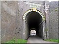
Single track tunnel under the railway linking Brindley Road with The Locks. Note no footpath and the change in roof heights halfway through.
Image: © Ian Rob
Taken: 12 May 2012
0.09 miles
6
Rugby - Hillmorton
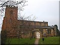
Church of St John the Baptist near the Locks
Image: © Ian Rob
Taken: 7 Jan 2006
0.10 miles
7
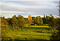
St. Johns Church Hillmorton
Taken from the tow path on the Oxford canal
Image: © Anthony Warren
Taken: 22 Jun 2006
0.10 miles
8
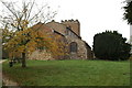
East end, St John the Baptist Church, Hillmorton
Image: © David Long
Taken: 29 Oct 2009
0.10 miles
9
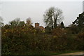
St John's Church, Hillmorton, from the roof of a narrow boat on the canal
Image: © David Long
Taken: 29 Oct 2009
0.11 miles
10

Nineteenth Century Benchmark on St John's Church
This nineteenth-century benchmark indicates a height of 97.646m above mean sea level at Newlyn.
Image: © Shantavira
Taken: 13 Jun 2017
0.11 miles