IMAGES TAKEN NEAR TO
McKinnell Crescent, RUGBY, CV21 4AU
Introduction
This page details the photographs taken nearby to McKinnell Crescent, CV21 4AU by members of the Geograph project.
The Geograph project started in 2005 with the aim of publishing, organising and preserving representative images for every square kilometre of Great Britain, Ireland and the Isle of Man.

There are currently over 7.5m images from over14,400 individuals and you can help contribute to the project by visiting https://www.geograph.org.uk
Image Map (Loading...)


Getting Data...Please wait
Leaflet Map data © OpenStreetMap
Images are licensed for reuse under creativecommons.org/licenses/by-sa/2.0
Notes
- Clicking on the map will re-center to the selected point.
- The higher the marker number, the further away the image location is from the centre of the postcode.
Image Listing (20 Images Found)
Images are licensed for reuse under creativecommons.org/licenses/by-sa/2.0
Image
Details
Distance
1
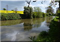
Hillmorton-Clifton Brook
The Brook flows under The West Coast Mainline towards Clifton.
Image: © Ian Rob
Taken: 30 Jan 2008
0.08 miles
4
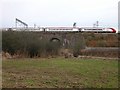
Hillmorton-West Coast Mainline
A London bound Express
Image: © Ian Rob
Taken: 30 Jan 2008
0.15 miles
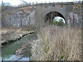
5
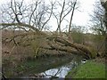
Hillmorton-Clifton Brook
Fallen trees across the brook.
Image: © Ian Rob
Taken: 30 Jan 2008
0.17 miles
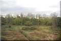
6
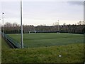
Rugby Town Football Club
New all weather training pitches next to the Football Ground.
Image: © Ian Rob
Taken: 30 Jan 2008
0.17 miles
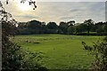
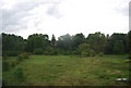
8
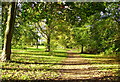
Bluebell Walk Abbots Farm Rugby
A pretty walk from Abbots Farm to Winfield Recreation ground
Image: © Anthony Warren
Taken: 29 Oct 2006
0.20 miles
9

Oxford Canal near Clifton upon Dunsmore
Image: © David Martin
Taken: 22 Jul 2016
0.21 miles