IMAGES TAKEN NEAR TO
Tennant Close, RUGBY, CV21 3UH
Introduction
This page details the photographs taken nearby to Tennant Close, CV21 3UH by members of the Geograph project.
The Geograph project started in 2005 with the aim of publishing, organising and preserving representative images for every square kilometre of Great Britain, Ireland and the Isle of Man.

There are currently over 7.5m images from over14,400 individuals and you can help contribute to the project by visiting https://www.geograph.org.uk
Image Map (Loading...)


Getting Data...Please wait
Leaflet Map data © OpenStreetMap
Images are licensed for reuse under creativecommons.org/licenses/by-sa/2.0
Notes
- Clicking on the map will re-center to the selected point.
- The higher the marker number, the further away the image location is from the centre of the postcode.
Image Listing (14 Images Found)
Images are licensed for reuse under creativecommons.org/licenses/by-sa/2.0
Image
Details
Distance
1
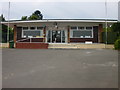
Rugby-The Grange Bowling Club
The Clubhouse on the land behind Stanley Road which was formerly the Smiths Industries sports ground.
Image: © Ian Rob
Taken: 15 May 2008
0.09 miles
2
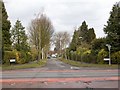
Stanley Road
View north east across Hillmorton Road up Stanley Road.
Image: © David P Howard
Taken: 4 Apr 2013
0.13 miles
3
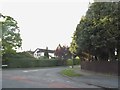
Langton Road at the junction of Hillmorton Road
Image: © David Howard
Taken: 21 May 2017
0.14 miles
4
Shenstone Avenue at the junction of Hillmorton Road
Image: © David Howard
Taken: 21 May 2017
0.16 miles
6
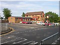
Rugby - Abbotts Farm
Jolly Abbott Public house in Lower Hillmorton Road.
Image: © Ian Rob
Taken: 11 Jun 2006
0.17 miles
7
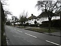
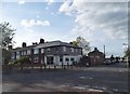
Rugby-Lower Hillmorton Road
Semi-detached houses on one side of the road.
Image: © Ian Rob
Taken: 28 Feb 2010
0.19 miles
8
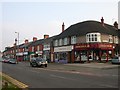
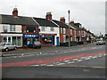
Rugby - Hillmorton Paddox
Parade of shops on Hillmorton Road.
Image: © Ian Rob
Taken: 15 Oct 2006
0.19 miles
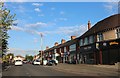
9
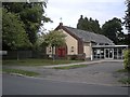
Rugby-Saint George's Church Hall
Also used as a Pre-School Nursery.
Image: © Ian Rob
Taken: 29 Aug 2011
0.20 miles
10
Rugby-Hillmorton Road
A mixture of shops and houses on the Paddox near the junction with Kingsley Avenue
Image: © Ian Rob
Taken: 16 Nov 2008
0.21 miles