IMAGES TAKEN NEAR TO
Osier Close, RUGBY, CV21 1UT
Introduction
This page details the photographs taken nearby to Osier Close, CV21 1UT by members of the Geograph project.
The Geograph project started in 2005 with the aim of publishing, organising and preserving representative images for every square kilometre of Great Britain, Ireland and the Isle of Man.

There are currently over 7.5m images from over14,400 individuals and you can help contribute to the project by visiting https://www.geograph.org.uk
Image Map
Images are licensed for reuse under creativecommons.org/licenses/by-sa/2.0
Notes
- Clicking on the map will re-center to the selected point.
- The higher the marker number, the further away the image location is from the centre of the postcode.
Image Listing (8 Images Found)
Images are licensed for reuse under creativecommons.org/licenses/by-sa/2.0
Image
Details
Distance
1
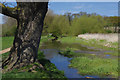
Brownsover Arm, Oxford Canal
The Brownsover Arm, which heads northwards from the main canal through the Swift Valley, is a relic of the original contour canal designed by James Brindley. A bold plan was executed in the 1820s to shorten the canal between Braunston and Coventry by using cuttings, embankments, tunnels and aqueducts to reduce the length by almost 14 miles. This left a number of redundant stretches some of which have completely disappeared while others, including this one, still have water but are no longer navigable. The canal here forms part of the Swift Valley Nature Reserve.
Image: © Stephen McKay
Taken: 16 Apr 2014
0.11 miles
2
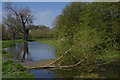
Brownsover Arm, Oxford Canal
The Brownsover Arm, which heads northwards from the main canal through the Swift Valley, is a relic of the original contour canal designed by James Brindley. A bold plan was executed in the 1820s to shorten the canal between Braunston and Coventry by using cuttings, embankments, tunnels and aqueducts to reduce the length by almost 14 miles. This left a number of redundant stretches some of which have completely disappeared while others, including this one, still have water but are no longer navigable. In this view a tree has fallen blocking the old canal.
Image: © Stephen McKay
Taken: 16 Apr 2014
0.13 miles
3
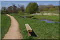
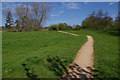
Swift Valley Nature Reserve
The nature reserve, consisting mainly of grassland and the disused Brownsover Canal Arm (seen here), is owned by Rugby Borough Council and managed by Warwickshire Wildlife Trust. The paths here are designed to be accessible for disabled people.
Image: © Stephen McKay
Taken: 16 Apr 2014
0.14 miles
4
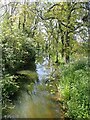
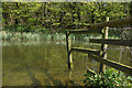
Water Lily pads on the Brownsover Arm
This tranquil stretch of the disused Brownsover Arm of the Oxford Canal features numerous rafts of water lily (Nymphaeaceae) pads; it's a pity they weren't in bloom as they have beautiful flowers that float on the water.
Image: © Rob Farrow
Taken: 30 May 2021
0.15 miles
5
Swift Valley Nature Reserve
The nature reserve, consisting mainly of grassland and a disused canal, is owned by Rugby Borough Council and managed by Warwickshire Wildlife Trust. The paths here are designed to be accessible for disabled people.
Image: © Stephen McKay
Taken: 16 Apr 2014
0.18 miles
6
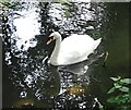
Mute Swan (Cygnus olor) on Brownsover Arm
The Mute Swan (Cygnus olor) is one of the world's heaviest flying birds with a weight for males of up to 20kg (44lbs)
The example seen here is probably more like 11kg (23lbs) - it is probably a male as it has a notable 'knob' at the top of its beak (females have these too but they're usually less prominent).
This one was floating about on the disused Brownsover Arm of the Oxford Canal.
Cf (probable) female with cygnets Image]
Image: © Rob Farrow
Taken: 30 May 2021
0.20 miles
7
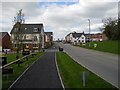
Rugby-Eden Park
A new housing development in north Rugby, close to Brownsover, with views over Swift Valley.
Image: © Ian Rob
Taken: 5 May 2013
0.22 miles
8
Brownsover Arm, Oxford Canal
The Brownsover Arm, which heads northwards from the main canal through the Swift Valley, is a relic of the original contour canal designed by James Brindley. A bold plan was executed in the 1820s to shorten the canal between Braunston and Coventry by using cuttings, embankments, tunnels and aqueducts to reduce the length by almost 14 miles. This left a number of redundant stretches some of which have completely disappeared while others, including this one, still have water but are no longer navigable.
Image: © Stephen McKay
Taken: 16 Apr 2014
0.22 miles