IMAGES TAKEN NEAR TO
Shackerstone Road, NUNEATON, CV13 6LX
Introduction
This page details the photographs taken nearby to Shackerstone Road, CV13 6LX by members of the Geograph project.
The Geograph project started in 2005 with the aim of publishing, organising and preserving representative images for every square kilometre of Great Britain, Ireland and the Isle of Man.

There are currently over 7.5m images from over14,400 individuals and you can help contribute to the project by visiting https://www.geograph.org.uk
Image Map
Images are licensed for reuse under creativecommons.org/licenses/by-sa/2.0
Notes
- Clicking on the map will re-center to the selected point.
- The higher the marker number, the further away the image location is from the centre of the postcode.
Image Listing (20 Images Found)
Images are licensed for reuse under creativecommons.org/licenses/by-sa/2.0
Image
Details
Distance
1
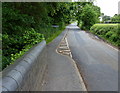
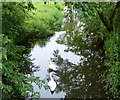
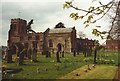
The road to Congerstone
Looking south from the bridge that crosses the River Sence.
Image: © Mat Fascione
Taken: 16 Jun 2013
0.03 miles
4
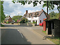
Main Street at Congerstone
Looking north from the village centre.
Image: © Trevor Rickard
Taken: 16 May 2010
0.08 miles
5
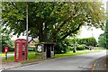
Congerstone Green
Bus stop, phone box and war memorial.
Image: © Ian Rob
Taken: 29 Aug 2019
0.08 miles
8
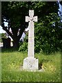
Congerstone War Memorial
War Memorial on the green at Barton Lane, Congerstone. SK 3682 0545
Image: © Mike W Hallett
Taken: 5 Jun 2009
0.09 miles
10
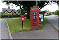
Telephone box on the Main Street of Congerstone
Image: © Mat Fascione
Taken: 16 Jun 2013
0.10 miles