IMAGES TAKEN NEAR TO
Sheepy Road, NUNEATON, CV13 6LE
Introduction
This page details the photographs taken nearby to Sheepy Road, CV13 6LE by members of the Geograph project.
The Geograph project started in 2005 with the aim of publishing, organising and preserving representative images for every square kilometre of Great Britain, Ireland and the Isle of Man.

There are currently over 7.5m images from over14,400 individuals and you can help contribute to the project by visiting https://www.geograph.org.uk
Image Map
Images are licensed for reuse under creativecommons.org/licenses/by-sa/2.0
Notes
- Clicking on the map will re-center to the selected point.
- The higher the marker number, the further away the image location is from the centre of the postcode.
Image Listing (20 Images Found)
Images are licensed for reuse under creativecommons.org/licenses/by-sa/2.0
Image
Details
Distance
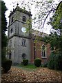
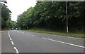
2
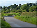
A bend in Upton Lane
In the distance is the tower of St Botolph Church in the village of Sibson.
Image: © Mat Fascione
Taken: 18 Aug 2013
0.08 miles
5
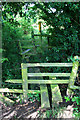
Stiles and Footbridge
On the path from Sibson to Sheepy.
Image: © David Lally
Taken: 8 Aug 2009
0.12 miles
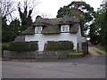
6
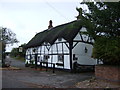
The Cock, Sibson
Thatched pub on Sheepy Road.
Image: © JThomas
Taken: 2 Nov 2013
0.14 miles
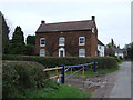
9
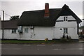
The Cock Inn, Sibson
It sounds like Benny Hill visited the pub a few times.
Image: © David Howard
Taken: 15 Aug 2021
0.14 miles
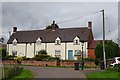
10
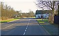
A444 Twycross Road in Sibson, Leicestershire
The thatched building is the Cock Inn on the corner of Sheepy Road.
Image: © Mat Fascione
Taken: 9 Feb 2008
0.14 miles