IMAGES TAKEN NEAR TO
Wykin Road, NUNEATON, CV13 6JL
Introduction
This page details the photographs taken nearby to Wykin Road, CV13 6JL by members of the Geograph project.
The Geograph project started in 2005 with the aim of publishing, organising and preserving representative images for every square kilometre of Great Britain, Ireland and the Isle of Man.

There are currently over 7.5m images from over14,400 individuals and you can help contribute to the project by visiting https://www.geograph.org.uk
Image Map (Loading...)


Getting Data...Please wait
Leaflet Map data © OpenStreetMap
Images are licensed for reuse under creativecommons.org/licenses/by-sa/2.0
Notes
- Clicking on the map will re-center to the selected point.
- The higher the marker number, the further away the image location is from the centre of the postcode.
Image Listing (26 Images Found)
Images are licensed for reuse under creativecommons.org/licenses/by-sa/2.0
Image
Details
Distance
1
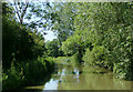
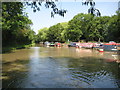
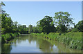
The Ashby Canal near Higham on the Hill, Leicestershire
North-west of Wykin Bridge (No 21).
The canal is a very popular one for boaters because (at present) it has twenty-two miles with no locks to negotiate, and is mainly through rural and attractive countryside. It was opened in 1804, but never reached its intended destination of Ashby-de-la-Zouch.
Active effort is now being made to extend the canal beyond its present limit at Snarestone.
Image: © Roger D Kidd
Taken: 16 Jun 2010
0.05 miles
2
Ashby Canal near Higham on the Hill, Leicestershire
Looking south-east towards Hinckley.
Image: © Roger Kidd
Taken: 18 Jun 2010
0.06 miles
3
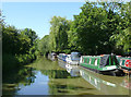
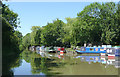
The Ashby Canal north of Wykin Bridge, Leicestershire
The moorings on the right extend from the former Barge Boatyard basin, which now provides well maintained private mooring facilities for boat owners. The canal is a very popular one for boaters because (at present) it has twenty-two miles with no locks to negotiate, and is mainly through rural and attractive countryside. It was opened in 1804, but never reached its intended destination of Ashby-de-la-Zouch.
Image: © Roger D Kidd
Taken: 16 Jun 2010
0.06 miles
4
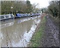
A very muddy Ashby Canal towpath
Looking south towards The Barge Boatyard and Wykin Bridge, close to the Leicestershire village of Higham on the Hill.
Image: © Mat Fascione
Taken: 26 Jan 2008
0.07 miles
5
Ashby Canal: Wykin Marina
Old Ordnance Survey maps show that this small marina occupies what was once a narrow triangular shaped field, hemmed in by the canal and two roads.
Image: © Nigel Cox
Taken: 11 Jul 2013
0.08 miles
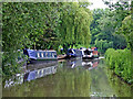
6
Ashby Canal moorings by Wykin Bridge, Leicestershire
This attractively maintained small marina provides long term private moorings in the basin formerly occupied by The Barge Boatyard.
Image: © Roger D Kidd
Taken: 16 Jun 2010
0.08 miles
7
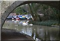
Wykin Bridge
Bridge number 21 along the Ashby Canal, The Barge Boatyard and long term moorings are visible through the arch of the bridge. The bridge carries Hinckley Lane across the canal.
Image: © Mat Fascione
Taken: 26 Jan 2008
0.08 miles
8
Ashby Canal, near Higham on the Hill
Seen from Wykin Bridge with the Barge boatyard on the right.
Image: © Stephen McKay
Taken: 6 Aug 2013
0.08 miles
9
The Ashby Canal near Higham on the Hill, Leicestershire
North-west of Wykin Bridge (No 21). Basin Bridge Lane runs alongside the canal here.
The canal is a very popular one for boaters because (at present) it has twenty-two miles with no locks to negotiate, and is mainly through rural and attractive countryside. It was opened in 1804, but never reached its intended destination of Ashby-de-la-Zouch.
Active effort is now being made to extend the canal beyond its present limit at Snarestone.
Image: © Roger D Kidd
Taken: 16 Jun 2010
0.08 miles
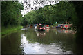
10
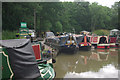
The Barge Boatyard, Ashby Canal
Long-term moorings are available here, just north of bridge 21.
Image: © Stephen McKay
Taken: 6 Aug 2013
0.09 miles