IMAGES TAKEN NEAR TO
Ryelands Crescent, NUNEATON, CV13 6EP
Introduction
This page details the photographs taken nearby to Ryelands Crescent, CV13 6EP by members of the Geograph project.
The Geograph project started in 2005 with the aim of publishing, organising and preserving representative images for every square kilometre of Great Britain, Ireland and the Isle of Man.

There are currently over 7.5m images from over14,400 individuals and you can help contribute to the project by visiting https://www.geograph.org.uk
Image Map
Images are licensed for reuse under creativecommons.org/licenses/by-sa/2.0
Notes
- Clicking on the map will re-center to the selected point.
- The higher the marker number, the further away the image location is from the centre of the postcode.
Image Listing (12 Images Found)
Images are licensed for reuse under creativecommons.org/licenses/by-sa/2.0
Image
Details
Distance
1
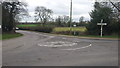
Mini roundabout at Stoke Golding
This roundabout is situated at the eastern edge of the village.
Image: © Peter Mackenzie
Taken: 21 Feb 2017
0.10 miles
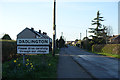
3
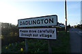
Welcome to Dadlington
Entering this Leicestershire village along Hinckley Road.
Image: © Mat Fascione
Taken: 26 Jan 2008
0.18 miles
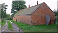
6
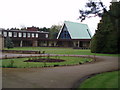
St. Martin's Convent, Stoke Golding
This establishment is discreetly tucked away down a secluded lane behind a catholic school.
Image: © Stephen McKay
Taken: 1 May 2006
0.22 miles
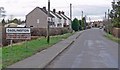
9
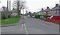
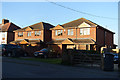
Hinckley Road in Stoke Golding
Looking west from the corner of Pine Close.
Image: © Mat Fascione
Taken: 26 Jan 2008
0.24 miles