IMAGES TAKEN NEAR TO
Market Bosworth Road, NUNEATON, CV13 6DH
Introduction
This page details the photographs taken nearby to Market Bosworth Road, CV13 6DH by members of the Geograph project.
The Geograph project started in 2005 with the aim of publishing, organising and preserving representative images for every square kilometre of Great Britain, Ireland and the Isle of Man.

There are currently over 7.5m images from over14,400 individuals and you can help contribute to the project by visiting https://www.geograph.org.uk
Image Map (Loading...)


Getting Data...Please wait
Leaflet Map data © OpenStreetMap
Images are licensed for reuse under creativecommons.org/licenses/by-sa/2.0
Notes
- Clicking on the map will re-center to the selected point.
- The higher the marker number, the further away the image location is from the centre of the postcode.
Image Listing (7 Images Found)
Images are licensed for reuse under creativecommons.org/licenses/by-sa/2.0
Image
Details
Distance
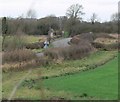
1
Fenn Lane Roman Road north of Dadlington, Leics
Image: © Rodney Burton
Taken: 15 Nov 2005
0.13 miles
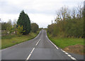
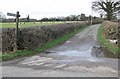
2
Crossroad on Fenn Lanes, Leicestershire
This is where Shenton Lane meets Fenn Lanes.
Image: © Mat Fascione
Taken: 26 Jan 2008
0.14 miles
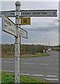
4
South along Shenton Lane
At the junction with Fenn Lanes in Leicestershire.
Image: © Mat Fascione
Taken: 26 Jan 2008
0.16 miles
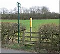
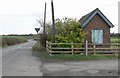
5
Entrance to Apple Orchard Farm
Along the former Roman Road now known as Fenn Lanes in Leicestershire.
Image: © Mat Fascione
Taken: 26 Jan 2008
0.19 miles
6
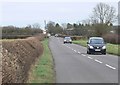
Fenn Lanes near Apple Orchard Farm
Looking east along the former Roman Road now known as Fenn Lanes in Leicestershire.
Image: © Mat Fascione
Taken: 26 Jan 2008
0.19 miles