IMAGES TAKEN NEAR TO
Barr Lane, NUNEATON, CV13 6AW
Introduction
This page details the photographs taken nearby to Barr Lane, CV13 6AW by members of the Geograph project.
The Geograph project started in 2005 with the aim of publishing, organising and preserving representative images for every square kilometre of Great Britain, Ireland and the Isle of Man.

There are currently over 7.5m images from over14,400 individuals and you can help contribute to the project by visiting https://www.geograph.org.uk
Image Map
Images are licensed for reuse under creativecommons.org/licenses/by-sa/2.0
Notes
- Clicking on the map will re-center to the selected point.
- The higher the marker number, the further away the image location is from the centre of the postcode.
Image Listing (6 Images Found)
Images are licensed for reuse under creativecommons.org/licenses/by-sa/2.0
Image
Details
Distance
3
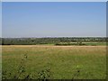
View from Harper's Hill
The view from the lane leading to Grange Farm. The fields in the foreground are in this square whilst Stoke Golding can be seen amongst the trees in the distance.
Image: © David Stowell
Taken: 21 Sep 2006
0.11 miles
4
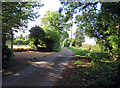
Barr Lane
Barr Lane serves a few isolated homes south of Higham-on-the-Hill.
Image: © Peter Mackenzie
Taken: 16 Jan 2018
0.14 miles
5
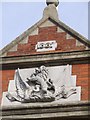
Date stamp on Building (Higham Green Hall)
The building in this square was built in 1887
Image: © Richard cattel
Taken: 13 Feb 2007
0.23 miles
6
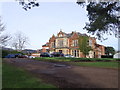
Hijaz College (formerly Higham Green College)
Asked the permission of the nice people at Hijaz if I could take some pictures of the college and they agreed. This building and its grounds have had many uses over the years including, college, school, and hospital. It is currently an Islamic private school and is being renovated. Thanks the People at Hijaz for letting me take these pictures.
Image: © Richard cattel
Taken: 13 Feb 2007
0.25 miles