IMAGES TAKEN NEAR TO
Heath Road, NUNEATON, CV13 0NG
Introduction
This page details the photographs taken nearby to Heath Road, CV13 0NG by members of the Geograph project.
The Geograph project started in 2005 with the aim of publishing, organising and preserving representative images for every square kilometre of Great Britain, Ireland and the Isle of Man.

There are currently over 7.5m images from over14,400 individuals and you can help contribute to the project by visiting https://www.geograph.org.uk
Image Map
Images are licensed for reuse under creativecommons.org/licenses/by-sa/2.0
Notes
- Clicking on the map will re-center to the selected point.
- The higher the marker number, the further away the image location is from the centre of the postcode.
Image Listing (8 Images Found)
Images are licensed for reuse under creativecommons.org/licenses/by-sa/2.0
Image
Details
Distance
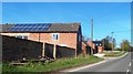
2
Garland Lane Farm
At the junction of Heath Road and Garland Lane.
Image: © Mat Fascione
Taken: 8 Mar 2009
0.06 miles
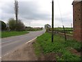
3
Burnt wreckage
It looked like a van or lorry was burnt out at the side of Bagworth road.
Image: © Mat Fascione
Taken: 27 Aug 2007
0.07 miles
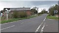
4
B585 Bagworth Road
Looking towards Newbold Heath. The minor road to the left is Heath Road and crosses the southern edge of Bagworth Heath.
Image: © Andrew Tatlow
Taken: 25 Apr 2006
0.11 miles
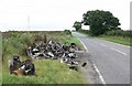
6
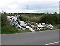
Fly tipping
An eyesore on the side of Heath Road in Leicestershire.
Image: © Mat Fascione
Taken: 27 Aug 2007
0.20 miles
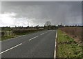
7
Stormy weather and pylons
Looking north-east from Bagworth Road.
Image: © Mat Fascione
Taken: 8 Mar 2009
0.20 miles
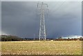
8
Fields north of Heath Road, Leicestershire
Image: © Mat Fascione
Taken: 27 Aug 2007
0.24 miles