IMAGES TAKEN NEAR TO
Long Street, BEDWORTH, CV12 9JZ
Introduction
This page details the photographs taken nearby to Long Street, CV12 9JZ by members of the Geograph project.
The Geograph project started in 2005 with the aim of publishing, organising and preserving representative images for every square kilometre of Great Britain, Ireland and the Isle of Man.

There are currently over 7.5m images from over14,400 individuals and you can help contribute to the project by visiting https://www.geograph.org.uk
Image Map (Loading...)


Getting Data...Please wait
Leaflet Map data © OpenStreetMap
Images are licensed for reuse under creativecommons.org/licenses/by-sa/2.0
Notes
- Clicking on the map will re-center to the selected point.
- The higher the marker number, the further away the image location is from the centre of the postcode.
Image Listing (18 Images Found)
Images are licensed for reuse under creativecommons.org/licenses/by-sa/2.0
Image
Details
Distance
4
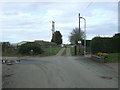
Long Street, Ryton
Becomes a private track towards Hall Grounds Farm.
Image: © JThomas
Taken: 4 Mar 2017
0.08 miles
5

Elizabeth II postbox on Wolvey Road
Postbox No. CV12 574.
See Image] for context.
Image: © JThomas
Taken: 4 Mar 2017
0.14 miles
6
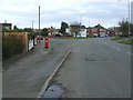
Wolvey Road (B4109), Ryton
Showing position of Postbox No. CV12 574.
See Image] for postbox.
Image: © JThomas
Taken: 4 Mar 2017
0.14 miles
7
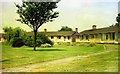
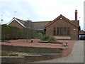
Oakham Crescent, Bulkington, 1975
Retirement bungalows built in the 1950's or early 1960's.
Image: © John Brightley
Taken: Unknown
0.17 miles
8
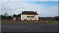
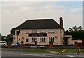
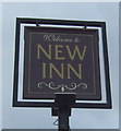
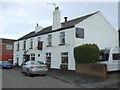
The New Inn
The New Inn is due for demolition and planning permission is given for a housing development on the site.
Image: © Peter Mackenzie
Taken: 17 Nov 2017
0.21 miles