IMAGES TAKEN NEAR TO
Sandby Close, BEDWORTH, CV12 8UB
Introduction
This page details the photographs taken nearby to Sandby Close, CV12 8UB by members of the Geograph project.
The Geograph project started in 2005 with the aim of publishing, organising and preserving representative images for every square kilometre of Great Britain, Ireland and the Isle of Man.

There are currently over 7.5m images from over14,400 individuals and you can help contribute to the project by visiting https://www.geograph.org.uk
Image Map (Loading...)


Getting Data...Please wait
Leaflet Map data © OpenStreetMap
Images are licensed for reuse under creativecommons.org/licenses/by-sa/2.0
Notes
- Clicking on the map will re-center to the selected point.
- The higher the marker number, the further away the image location is from the centre of the postcode.
Image Listing (2 Images Found)
Images are licensed for reuse under creativecommons.org/licenses/by-sa/2.0
Image
Details
Distance
1
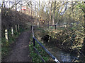
The River Sowe emerges from a culvert, Bedworth Sloughs
The culvert leads the young river from west of the A444 dual carriageway, which is on an embankment, upper left. It feeds the lake called Bedworth Sloughs: "one of Nuneaton & Bedworth's Wildspaces." The footpath disgorges to Ilford Close.
Image: © Robin Stott
Taken: 31 Jan 2018
0.17 miles
2
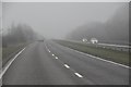
Nuneaton and Bedworth : A444 Road
Looking along the A444 which heads towards Nuneaton.
Image: © Lewis Clarke
Taken: 6 Feb 2012
0.22 miles