IMAGES TAKEN NEAR TO
Croft Fields, BEDWORTH, CV12 8QT
Introduction
This page details the photographs taken nearby to Croft Fields, CV12 8QT by members of the Geograph project.
The Geograph project started in 2005 with the aim of publishing, organising and preserving representative images for every square kilometre of Great Britain, Ireland and the Isle of Man.

There are currently over 7.5m images from over14,400 individuals and you can help contribute to the project by visiting https://www.geograph.org.uk
Image Map
Images are licensed for reuse under creativecommons.org/licenses/by-sa/2.0
Notes
- Clicking on the map will re-center to the selected point.
- The higher the marker number, the further away the image location is from the centre of the postcode.
Image Listing (65 Images Found)
Images are licensed for reuse under creativecommons.org/licenses/by-sa/2.0
Image
Details
Distance
1
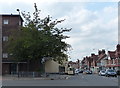
Newtown Road near Bedworth town centre
Image: © Mat Fascione
Taken: 28 Sep 2014
0.09 miles
2
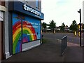
Coronavirus rainbow, Bedworth
Tweezers Beauty Bar at the corner of Mill Street and George Street Ringway, offering thanks to key workers on their shop shutters.
Image: © A J Paxton
Taken: 5 Jun 2021
0.09 miles
3
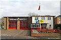
Bedworth fire station
Bedworth fire station, Park Road, Bedworth, Warwickshire
Image: © Kevin Hale
Taken: 25 Nov 2006
0.10 miles
4
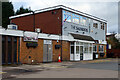
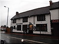
The Saunders, Bedworth
At first glance this could be taken for a pub, albeit one housed in a particularly unattractive box of a building. It is, in fact, a private club whose full name is the Saunders Hall Working Men's Club. It is situated on Saunders Avenue close to the town centre.
Image: © Stephen McKay
Taken: 18 Nov 2022
0.11 miles
5
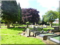
Bedworth Cemetery
Seen from its northern edge. http://www.nuneatonandbedworth.gov.uk/info/200424/cemeteries/147/cemetery_information
Image: © Mike Faherty
Taken: 8 Jun 2014
0.13 miles
6
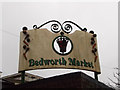
Bedworth Market sign
Seen from Mill Street
Image: © Niki Walton
Taken: 14 Nov 2015
0.14 miles
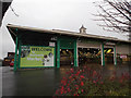
7
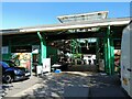
Bedworth Market
The covered market in Bedworth, Warwickshire - established 1996.
Image: © Pebble
Taken: 7 Aug 2020
0.15 miles
9
Bedworth Market
The last stallholders packing up on a Saturday afternoon.
Image: © Niki Walton
Taken: 14 Nov 2015
0.16 miles
10
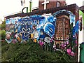
Detail of Bedworth civic mural, Mill Street
The mural is painted on a wall in Mill Street, in front of the Methodist church and the market hall, a very prominent site in the town. It continues round to the left with Armistice Day images of war, coal mining and red poppies, not visible here. It was painted in 2020, as the coronavirus pandemic imagery suggests. The artist is Katie Sullivan, who signs as Katie O-Art, and the mural was commissioned and paid for by a local councillor, Bill Hancox; see this article in Bedworth Nub News https://bedworth.nub.news/n/borough-councillor-commissions-new-mural-to-bring-bedworth39s-proud-history-to-life .
The bee, symbol of industriousness, appears of the Bedworth coat of arms, as does the white ribbon with its three loops, which alludes to the uniting of the three parishes of Bedworth, Bulkington and Exhall in the modern town, and perhaps also to the historic ribbon-weaving industry. http://www.civicheraldry.co.uk/warwicks_ob.html#bedworth%20udc
To the right can be seen the Bedworth water tower, the town's most prominent landmark, while to the left stand the Nicholas Chamberlaine almshouses, the most striking building in the town centre. The bun refers to Founder's Day, known locally as Bun Day, when Rector Nicholas Chamberlaine, the founder of the almshouses, is remembered, and children at local Church of England schools are each given a currant bun; see the website of the charitable trust here https://nicholaschamberlainetrusts.org.uk/annual-events .
Image: © A J Paxton
Taken: 4 Aug 2021
0.16 miles